< ISS018-E-11174 >
| NASA Photo ID | ISS018-E-11174 |
| Focal Length | 800mm |
| Date taken | 2008.12.06 |
| Time taken | 19:19:59 GMT |
Resolutions offered for this image:
1000 x 664 pixels 540 x 359 pixels 720 x 480 pixels 3072 x 2098 pixels 640 x 437 pixels
1000 x 664 pixels 540 x 359 pixels 720 x 480 pixels 3072 x 2098 pixels 640 x 437 pixels


Spacecraft nadir point: 49.3° N, 88.2° W
Photo center point: 48.4° N, 89.3° W
Photo center point by machine learning:
Photo center point: 48.4° N, 89.3° W
Photo center point by machine learning:
Nadir to Photo Center: Southwest
Spacecraft Altitude: 185 nautical miles (343km)
Country or Geographic Name: | CANADA-O |
Features: | THUNDER BAY, SNOW |
| Features Found Using Machine Learning: | |
Cloud Cover Percentage: | 10 (1-10)% |
Sun Elevation Angle: | 15° |
Sun Azimuth: | 203° |
Camera: | Nikon D2Xs Electronic Still Camera |
Focal Length: | 800mm |
Camera Tilt: | 25 degrees |
Format: | 4288E: 4288 x 2848 pixel CMOS sensor, RGBG imager color filter |
Film Exposure: | |
| Additional Information | |
| Width | Height | Annotated | Cropped | Purpose | Links |
|---|---|---|---|---|---|
| 1000 pixels | 664 pixels | No | Yes | Earth From Space collection | Download Image |
| 540 pixels | 359 pixels | Yes | Yes | Earth From Space collection | Download Image |
| 720 pixels | 480 pixels | Yes | Yes | NASA's Earth Observatory web site | Download Image |
| 3072 pixels | 2098 pixels | No | No | Download Image | |
| 640 pixels | 437 pixels | No | No | Download Image |
Download Packaged File
Download a Google Earth KML for this Image
View photo footprint information
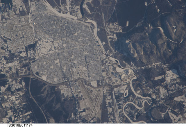
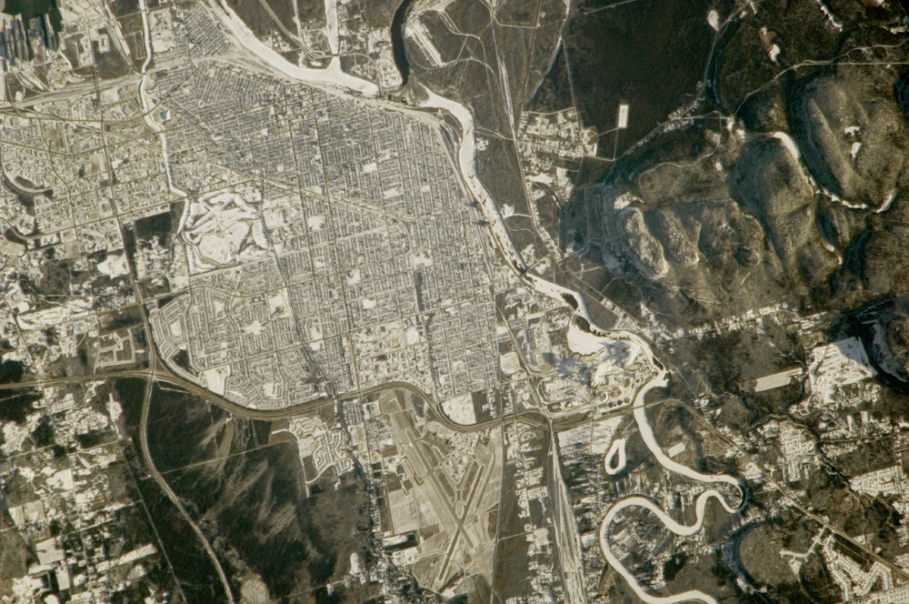
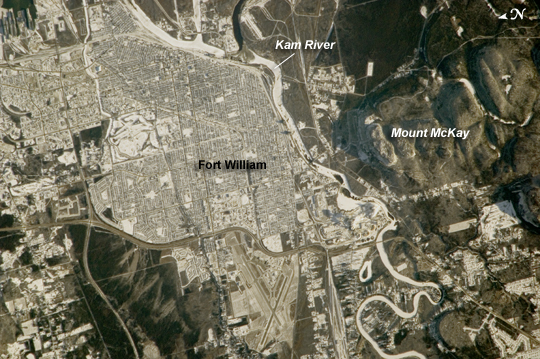
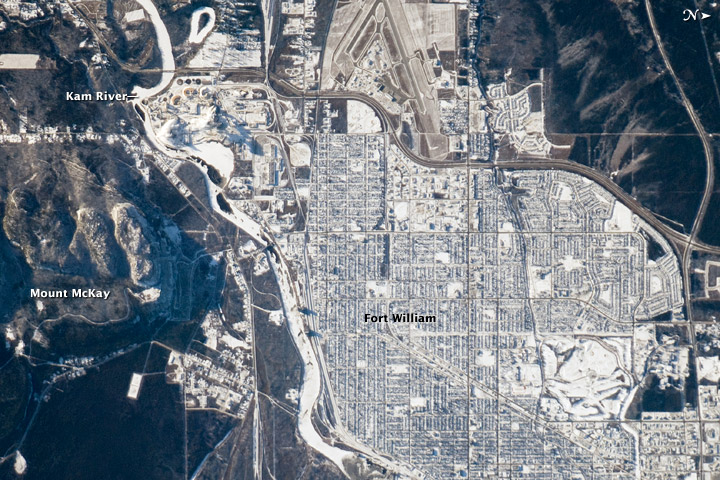
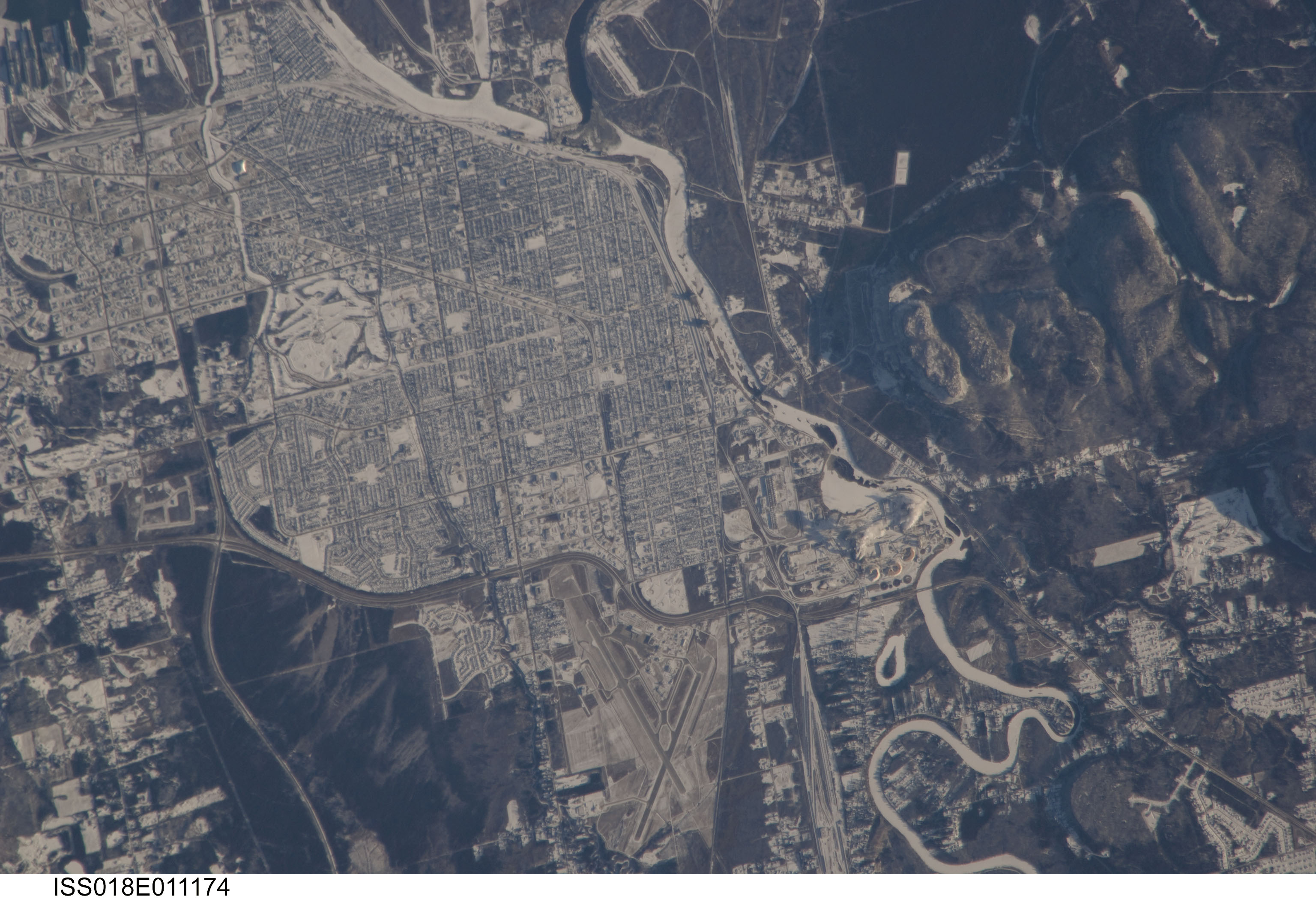
No GeoTIFF is available for this photo.Image Caption: City of Thunder Bay, Ontario, Canada
Located on the shores of Lake Superior (regional view), the metropolitan area of Thunder Bay is one of the largest in the Province of Ontario. It is also the major port providing access to the Great Lakes for central Canada's grain products. The city of Thunder Bay is relatively new; it was incorporated in 1970 by combining the cities of Fort William (shown in this astronaut photograph) and Port Arthur with the townships of Neebing and McIntyre. While the spread of separate municipalities into a larger contiguous metropolitan area is common (urban geographers call the process agglomeration), it is less common for distinct cities to merge into a new political entity.
This detailed astronaut photograph is centered on the older city of Fort William, in the southern portion of Thunder Bay. Winter snows outline the street grid of the city, while parks appear as roughly rectangular areas of unbroken white snow. Built materials (buildings, streets) appear light gray, while vegetated areas and the rock outcrop near Mount McKay are dark green to dark gray. The Kam River to the south of Fort William is ice-covered, and has an even covering of snow that traces the river channel.
