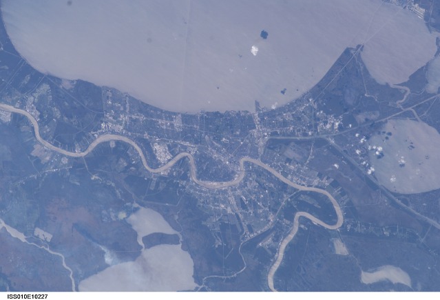
< ISS010-E-10227 >
| NASA Photo ID | ISS010-E-10227 |
| Focal Length | 180mm |
| Date taken | 2004.12.11 |
| Time taken | 19:50:54 GMT |


Spacecraft nadir point: 31.8° N, 88.8° W
Photo center point: 30.0° N, 90.0° W
Photo center point by machine learning:
Photo center point: 30.0° N, 90.0° W
Photo center point by machine learning:
Nadir to Photo Center: Southwest
Spacecraft Altitude: 188 nautical miles (348km)
Country or Geographic Name: | USA-LOUISIANA |
Features: | NEW ORLEANS, MISSISSIPPI R., L. |
| Features Found Using Machine Learning: | |
Cloud Cover Percentage: | 10 (1-10)% |
Sun Elevation Angle: | 28° |
Sun Azimuth: | 212° |
Camera: | Kodak DCS760c Electronic Still Camera |
Focal Length: | 180mm |
Camera Tilt: | 35 degrees |
Format: | 3060E: 3060 x 2036 pixel CCD, RGBG array |
Film Exposure: | |
| Additional Information | |
| Width | Height | Annotated | Cropped | Purpose | Links |
|---|---|---|---|---|---|
| 3032 pixels | 2064 pixels | No | No | Download Image | |
| 639 pixels | 435 pixels | No | No | Download Image |
Download Packaged File
Download a Google Earth KML for this Image
View photo footprint information
No GeoTIFF is available for this photo.Image Caption: ISS010-E-10227 (11 December 2004) --- Most of Greater New Orleans, Louisiana was captured with an electronic still camera as the Space Station made one of its many passes over the central Gulf of Mexico coast. In the almost vertical view, north is toward the top of the frame. New Orleans Lakefront Airport and a portion of the long causeway are recognizable features associated with Lake Ponchartrain in the top half of the frame. The Superdome is visible as a needle head sized object in the center of the image. The Mississippi River can be seen snaking horizontally through the picture.
