Geographic Region: INDIA
Feature: MOUTHS OF THE GANGES
|
Geographic Region: INDIA Feature: MOUTHS OF THE GANGES |
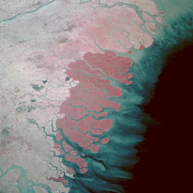 |
| STS61B-50-0007 Mouths of the Ganges River, India and Bangladesh November 1985 South of the confluence of the Ganges and Brahmaputra Rivers (not shown in this photograph) and north of the Bay of Bengal lies the vast Ganges Delta plain, approximately 220 miles (350 kilometers) wide. Parts of the delta, the world's largest, lie in both Bangladesh and the State of West Bengal, India. In this low-oblique, infrared photograph, the deep reds of healthy vegetation register the Sundarbans, an abundant mangrove swamp that is the largest remaining habitat of the Bengal tiger. The entire region is plagued almost yearly by severe storm surges and powerful low-pressure cyclones that arrive from the Bay of Bengal. Although death and destruction follow in the wake of these storms, the resilient survivors continue to cultivate crops of rice, sugar cane, and jute. |
| Images: | All Available Images Low-Resolution 109k |
|
| Mission: | STS61B |
|
| Roll - Frame: | 50 - 7 |
|
| Geographical Name: | INDIA |
|
| Features: | MOUTHS OF THE GANGES |
|
| Center Lat x Lon: | 22.0N x 89.0E |
|
| Film Exposure: | N | N=Normal exposure, U=Under exposed, O=Over exposed, F=out of Focus |
| Percentage of Cloud Cover-CLDP: | 10 |
|
| Camera:: | HB |
|
| Camera Tilt: | 38 | LO=Low Oblique, HO=High Oblique, NV=Near Vertical |
| Camera Focal Length: | 100 |
|
| Nadir to Photo Center Direction: | NE | The direction from the nadir to the center point, N=North, S=South, E=East, W=West |
| Stereo?: | N | Y=Yes there is an adjacent picture of the same area, N=No there isn't |
| Orbit Number: | 84 |
|
| Date: | 19851202 | YYYYMMDD |
| Time: | 071043 | GMT HHMMSS |
| Nadir Lat: | 20.1N |
Latitude of suborbital point of spacecraft |
| Nadir Lon: | 87.8E |
Longitude of suborbital point of spacecraft |
| Sun Azimuth: | 203 | Clockwise angle in degrees from north to the sun measured at the nadir point |
| Space Craft Altitude: | 173 | nautical miles |
| Sun Elevation: | 44 | Angle in degrees between the horizon and the sun, measured at the nadir point |
| Land Views: | COAST, FOREST, PLAIN |
|
| Water Views: | ESTUARY, RIVER, DELTA, SWAMP, SEDIMENT, BAY |
|
| Atmosphere Views: | |
|
| Man Made Views: | AGRICULTURE |
|
| City Views: | |
|
Photo is not associated with any sequences | ||
| NASA Home Page |
JSC Home Page |
JSC Digital Image Collection |
Earth Science & Remote Sensing |
|
This service is provided by the International Space Station program and the JSC Earth Science & Remote Sensing Unit, ARES Division, Exploration Integration Science Directorate.

|