Geographic Region: MEXICO
Feature: MEXICO CITY
|
Geographic Region: MEXICO Feature: MEXICO CITY |
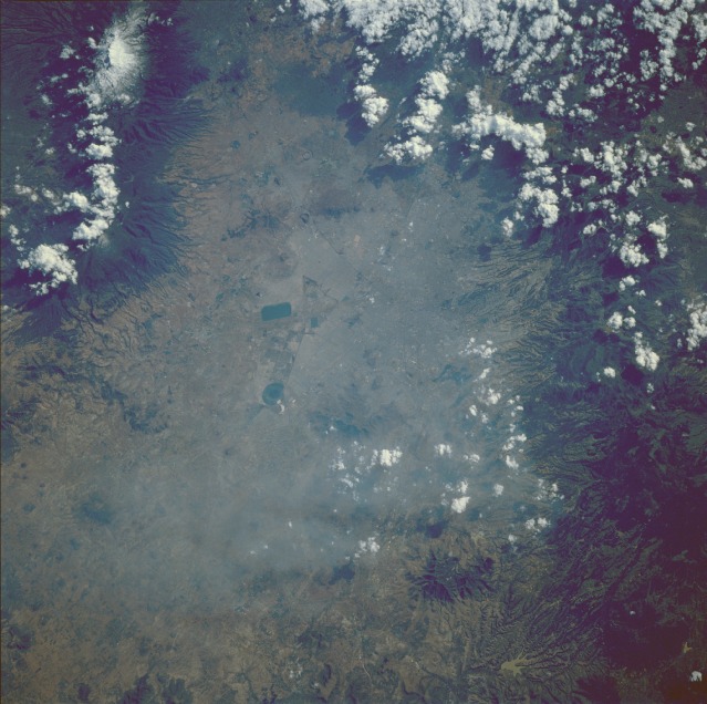 |
| STS61B-40-0065 Mexico City, Mexico November 1985 Although this photograph of the metropolitan Mexico City area is not very aesthetically pleasing because of substantial air pollution (hazy conditions, with the heaviest concentration visible northwest of the city), some street patterns can be seen at several points throughout the city. Manmade features also include two very large, dark shapes near the center of the photograph (one feature, circular; the other, rectangular). The rectangular shape is a water reservoir, and the circular feature appears to be a water holding facility (later imagery shows that this feature is now dry). The vegetated slopes (dark areas) on the surrounding volcanoes show the radial drainage patterns that are characteristic of most volcanoes throughout the world. Some clouds obscure the volcanic peaks located east of the city; however, the snow-capped peak near the town of Chiautzingo is visible. Mexico City presently has the world's second-largest metropolitan population with 22.5 million people. Some demographers have forecast an astounding total of between 40 and 50 million residents for greater Mexico City by 2010. In any case, Mexico City will become the world's largest single population center by the year 2000, surpassing metropolitan Tokyo. It is also noteworthy that the Mexico City region is part of the Ring of Fire (volcano-earthquake zone) that encircles the Pacific Ocean. Thus, this entire area is very susceptible to earthquakes and volcanic activity. |
| Images: | All Available Images Low-Resolution 125k |
|
| Mission: | STS61B |
|
| Roll - Frame: | 40 - 65 |
|
| Geographical Name: | MEXICO |
|
| Features: | MEXICO CITY |
|
| Center Lat x Lon: | 19.5N x 99W |
|
| Film Exposure: | N | N=Normal exposure, U=Under exposed, O=Over exposed, F=out of Focus |
| Percentage of Cloud Cover-CLDP: | 50 |
|
| Camera:: | HB |
|
| Camera Tilt: | 29 | LO=Low Oblique, HO=High Oblique, NV=Near Vertical |
| Camera Focal Length: | 250 |
|
| Nadir to Photo Center Direction: | SE | The direction from the nadir to the center point, N=North, S=South, E=East, W=West |
| Stereo?: | N | Y=Yes there is an adjacent picture of the same area, N=No there isn't |
| Orbit Number: | 46 |
|
| Date: | 19851129 | YYYYMMDD |
| Time: | 210847 | GMT HHMMSS |
| Nadir Lat: | 20.6N |
Latitude of suborbital point of spacecraft |
| Nadir Lon: | 100.5W |
Longitude of suborbital point of spacecraft |
| Sun Azimuth: | 224 | Clockwise angle in degrees from north to the sun measured at the nadir point |
| Space Craft Altitude: | 199 | nautical miles |
| Sun Elevation: | 32 | Angle in degrees between the horizon and the sun, measured at the nadir point |
| Land Views: | VOLCANO, VALLEY, BASIN |
|
| Water Views: | RESERVOIR |
|
| Atmosphere Views: | HAZE, SMOG |
|
| Man Made Views: | URBAN AREA, POLLUTION |
|
| City Views: | MEXICO CITY |
|
Photo is not associated with any sequences | ||
| NASA Home Page |
JSC Home Page |
JSC Digital Image Collection |
Earth Science & Remote Sensing |
|
This service is provided by the International Space Station program and the JSC Earth Science & Remote Sensing Unit, ARES Division, Exploration Integration Science Directorate.

|