Geographic Region: VENEZUELA
Feature: RIO CARONI-RES,ORINOCO R
|
Geographic Region: VENEZUELA Feature: RIO CARONI-RES,ORINOCO R |
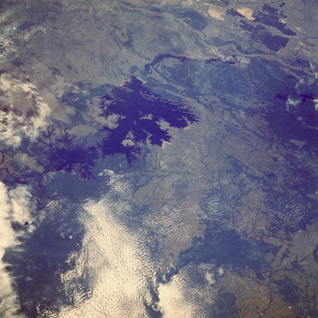 |
| STS61A-489-0012 Caroni River and Guri Reservoir, Venezuela October 1985 The dark blue waters of the Guri Reservoir in southeastern Venezuela are visible in the center of this northwest-looking, low-oblique photograph. The Guri Reservoir, built on the Caroni River in the early 1980s, provides water and electricity for steel plants and other industries around Guayana and irrigation projects along the Caroni River. Upon its completion in mid-1986, the dam produced more than 10 gigawatts of electricity, the first in the world to do so. The Caroni River, which originates in southeastern Venezuela near the border with Guyana, flows northward 550 miles (885 kilometers) and joins the sediment-filled Orinoco River near the city of Guayana (not easily discernible in the photograph). Before this photograph was taken, much forest (dark green) had been cleared south of the Orinoco River; subsequently, much land near the southern end of the reservoir and upstream of the Caroni River has been deforested, leading to silting problems within the reservoir. |
| Images: | All Available Images Low-Resolution 158k |
|
| Mission: | STS61A |
|
| Roll - Frame: | 489 - 12 |
|
| Geographical Name: | VENEZUELA |
|
| Features: | RIO CARONI-RES,ORINOCO R |
|
| Center Lat x Lon: | 7.5N x 62.5W |
|
| Film Exposure: | N | N=Normal exposure, U=Under exposed, O=Over exposed, F=out of Focus |
| Percentage of Cloud Cover-CLDP: | 40 |
|
| Camera:: | HB |
|
| Camera Tilt: | LO | LO=Low Oblique, HO=High Oblique, NV=Near Vertical |
| Camera Focal Length: | 100 |
|
| Nadir to Photo Center Direction: | The direction from the nadir to the center point, N=North, S=South, E=East, W=West |
|
| Stereo?: | Y | Y=Yes there is an adjacent picture of the same area, N=No there isn't |
| Orbit Number: | |
|
| Date: | 1985____ | YYYYMMDD |
| Time: | GMT HHMMSS |
|
| Nadir Lat: | N |
Latitude of suborbital point of spacecraft |
| Nadir Lon: | E |
Longitude of suborbital point of spacecraft |
| Sun Azimuth: | Clockwise angle in degrees from north to the sun measured at the nadir point |
|
| Space Craft Altitude: | nautical miles |
|
| Sun Elevation: | Angle in degrees between the horizon and the sun, measured at the nadir point |
|
| Land Views: | FOREST, HILL, VALLEY |
|
| Water Views: | RESERVOIR, RIVER |
|
| Atmosphere Views: | |
|
| Man Made Views: | AGRICULTURE, DAM |
|
| City Views: | |
|
Photo is not associated with any sequences | ||
| NASA Home Page |
JSC Home Page |
JSC Digital Image Collection |
Earth Science & Remote Sensing |
|
This service is provided by the International Space Station program and the JSC Earth Science & Remote Sensing Unit, ARES Division, Exploration Integration Science Directorate.

|