Geographic Region: USA-TEXAS
Feature: HOUSTON
|
Geographic Region: USA-TEXAS Feature: HOUSTON |
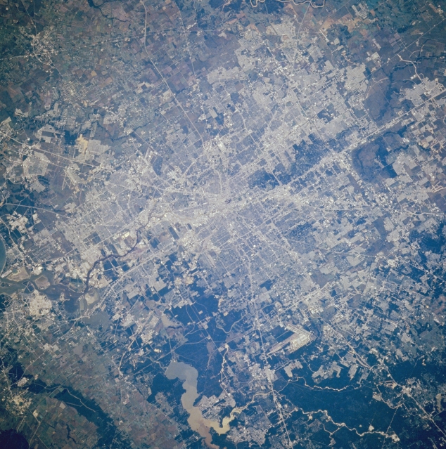 |
| STS61A-48-75 Houston, Texas, U.S.A. November 1985 Houston, the fourth most populous city in the United States and the third-busiest port in the United States, is featured in this southwest-looking, low-oblique photograph. Located 25 miles (40 kilometers) northwest of Galveston Bay (not visible) on the coastal plain, Houston is a great commercial, medical, financial, and industrial hub and is one of the world's major oil centers. Visible are sediment-laden Lake Houston, the source of much of Houston's drinking water; the runways of George Bush Intercontinental Airport west of the lake; and the small city of Alvin (upper left). Houston's continued growth began with the completion of the Houston Ship Channel in 1914. |
| Images: | All Available Images Low-Resolution 410k |
|
| Mission: | STS61A |
|
| Roll - Frame: | 48 - 75 |
|
| Geographical Name: | USA-TEXAS |
|
| Features: | HOUSTON |
|
| Center Lat x Lon: | 30.0N x 95.5W |
|
| Film Exposure: | N | N=Normal exposure, U=Under exposed, O=Over exposed, F=out of Focus |
| Percentage of Cloud Cover-CLDP: | 0 |
|
| Camera:: | HB |
|
| Camera Tilt: | 10 | LO=Low Oblique, HO=High Oblique, NV=Near Vertical |
| Camera Focal Length: | 250 |
|
| Nadir to Photo Center Direction: | W | The direction from the nadir to the center point, N=North, S=South, E=East, W=West |
| Stereo?: | Y | Y=Yes there is an adjacent picture of the same area, N=No there isn't |
| Orbit Number: | 64 |
|
| Date: | 19851103 | YYYYMMDD |
| Time: | 164047 | GMT HHMMSS |
| Nadir Lat: | 30.2N |
Latitude of suborbital point of spacecraft |
| Nadir Lon: | 95W |
Longitude of suborbital point of spacecraft |
| Sun Azimuth: | 153 | Clockwise angle in degrees from north to the sun measured at the nadir point |
| Space Craft Altitude: | 177 | nautical miles |
| Sun Elevation: | 40 | Angle in degrees between the horizon and the sun, measured at the nadir point |
| Land Views: | PLAIN |
|
| Water Views: | CHANNEL, LAKE |
|
| Atmosphere Views: | |
|
| Man Made Views: | URBAN AREA, HIGHWAY, AIRPORT |
|
| City Views: | |
|
Photo is not associated with any sequences | ||
| NASA Home Page |
JSC Home Page |
JSC Digital Image Collection |
Earth Science & Remote Sensing |
|
This service is provided by the International Space Station program and the JSC Earth Science & Remote Sensing Unit, ARES Division, Exploration Integration Science Directorate.

|