Geographic Region: ETHIOPIA
Feature: RED SEA COAST, LAVA FIELDS
|
Geographic Region: ETHIOPIA Feature: RED SEA COAST, LAVA FIELDS |
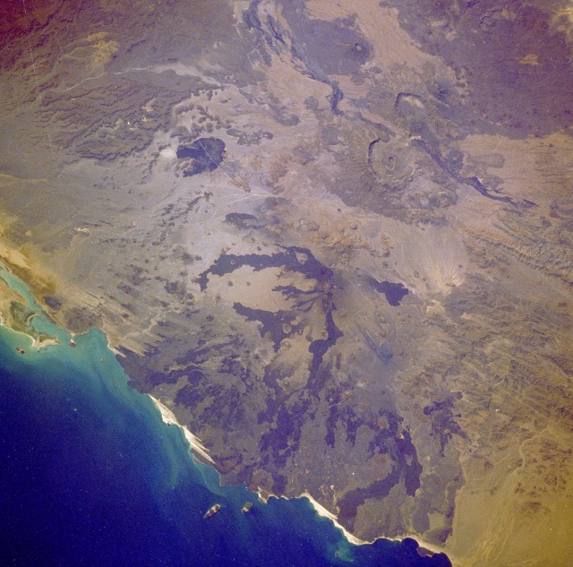 |
| STS61A-36-0097 Volcanoes, Eritrea November 1985 Most of the volcanoes featured in this photograph lie within Eritrea, a small country along the west bank of the Red Sea that gained its independence May 24, 1993. Several individual volcanoes captured in this near-vertical photograph can be located by their lava flow patterns or by their calderas. Dubbi Volcano, near the center of the photograph, is the source of the dark radiating lava flows that extend generally northward toward the Red Sea. Because darker lava generally indicates fairly recent flows, photographs such as this one provide an excellent tool for mapping the distribution pattern and extent of the lava flow. A much smaller recent lava flow, probably emanating from a fissure, is discernible east of Dubbi. Prior to the last Dubbi eruption in 1990, two other eruptions occurred during the mid-1800s. Two sizable calderas of extinct volcanoes (Nabro and Mallahle) are visible south-southwest of Dubbi. The small area of wind streaks (wind erosion) along the coast suggests that the predominate wind direction is southeast to northwest. |
| Images: | All Available Images Low-Resolution 137k |
|
| Mission: | STS61A |
|
| Roll - Frame: | 36 - 97 |
|
| Geographical Name: | ETHIOPIA |
|
| Features: | RED SEA COAST, LAVA FIELDS |
|
| Center Lat x Lon: | 13.5N x 42.0E |
|
| Film Exposure: | N | N=Normal exposure, U=Under exposed, O=Over exposed, F=out of Focus |
| Percentage of Cloud Cover-CLDP: | 0 |
|
| Camera:: | HB |
|
| Camera Tilt: | 33 | LO=Low Oblique, HO=High Oblique, NV=Near Vertical |
| Camera Focal Length: | 250 |
|
| Nadir to Photo Center Direction: | S | The direction from the nadir to the center point, N=North, S=South, E=East, W=West |
| Stereo?: | Y | Y=Yes there is an adjacent picture of the same area, N=No there isn't |
| Orbit Number: | 42 |
|
| Date: | 19851102 | YYYYMMDD |
| Time: | 071310 | GMT HHMMSS |
| Nadir Lat: | 15.3N |
Latitude of suborbital point of spacecraft |
| Nadir Lon: | 42.7E |
Longitude of suborbital point of spacecraft |
| Sun Azimuth: | 139 | Clockwise angle in degrees from north to the sun measured at the nadir point |
| Space Craft Altitude: | 176 | nautical miles |
| Sun Elevation: | 51 | Angle in degrees between the horizon and the sun, measured at the nadir point |
| Land Views: | VOLCANO, RIFT, FAULT, ESCARPMENT |
|
| Water Views: | |
|
| Atmosphere Views: | |
|
| Man Made Views: | |
|
| City Views: | |
|
Photo is not associated with any sequences | ||
| NASA Home Page |
JSC Home Page |
JSC Digital Image Collection |
Earth Science & Remote Sensing |
|
This service is provided by the International Space Station program and the JSC Earth Science & Remote Sensing Unit, ARES Division, Exploration Integration Science Directorate.

|