
Geographic Region: USA-NORTH DAKOTA
Feature: PEACE GARDEN
|
Geographic Region: USA-NORTH DAKOTA Feature: PEACE GARDEN |
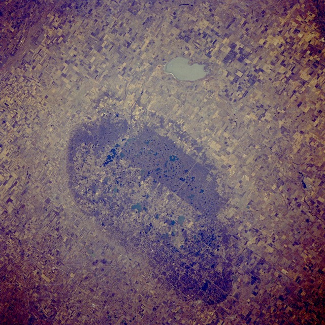 |
| STS61A-35-0082 International Peace Garden, North-Central North Dakota, U.S.A., and Southwest Manitoba, Canada November 1985 The International Peace Garden is an international park that straddles the United States-Canada border. This physiographic phenomenon is slightly elevated [by several hundred feet (tens of meters)] from the surrounding flatland farming of the Great Plains. The region is in the heart of the spring wheat belt of north-central North Dakota and southwest Manitoba. A discernible line measuring 2000 feet (610 meters) outlines the perimeter of the rather oval International Peace Garden. The 49th parallel, the east-west alignment of the international border through the Peace Garden, can be distinguished by the dense vegetation and numerous small lakes (darker areas) on the Canadian side of the border and the farmland on the U.S. side. Whitewater Lake in southwestern Manitoba lies approximately 7 miles (11 kilometers) north of the International Peace Garden. |
| Images: | All Available Images Low-Resolution 194k |
|
| Mission: | STS61A |
|
| Roll - Frame: | 35 - 82 |
|
| Geographical Name: | USA-NORTH DAKOTA |
|
| Features: | PEACE GARDEN |
|
| Center Lat x Lon: | 49.0N x 100W |
|
| Film Exposure: | N | N=Normal exposure, U=Under exposed, O=Over exposed, F=out of Focus |
| Percentage of Cloud Cover-CLDP: | 0 |
|
| Camera:: | HB |
|
| Camera Tilt: | 40 | LO=Low Oblique, HO=High Oblique, NV=Near Vertical |
| Camera Focal Length: | 250 |
|
| Nadir to Photo Center Direction: | W | The direction from the nadir to the center point, N=North, S=South, E=East, W=West |
| Stereo?: | N | Y=Yes there is an adjacent picture of the same area, N=No there isn't |
| Orbit Number: | 34 |
|
| Date: | 19851101 | YYYYMMDD |
| Time: | 191620 | GMT HHMMSS |
| Nadir Lat: | 48.9N |
Latitude of suborbital point of spacecraft |
| Nadir Lon: | 97.5W |
Longitude of suborbital point of spacecraft |
| Sun Azimuth: | 196 | Clockwise angle in degrees from north to the sun measured at the nadir point |
| Space Craft Altitude: | 181 | nautical miles |
| Sun Elevation: | 25 | Angle in degrees between the horizon and the sun, measured at the nadir point |
| Land Views: | PLAIN, HILL |
|
| Water Views: | LAKE |
|
| Atmosphere Views: | |
|
| Man Made Views: | AGRICULTURE |
|
| City Views: | |
|
Photo is not associated with any sequences | ||
| NASA Home Page |
JSC Home Page |
JSC Digital Image Collection |
Earth Science & Remote Sensing |
|
This service is provided by the International Space Station program and the JSC Earth Science & Remote Sensing Unit, ARES Division, Exploration Integration Science Directorate.

|