Geographic Region: CAMBODIA
Feature: MEKONG RIVER
|
Geographic Region: CAMBODIA Feature: MEKONG RIVER |
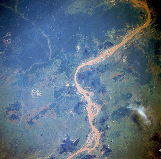 |
| STS61A-32-0026 Mekong River, Cambodia (Kampuchea) October 1985 One of the great rivers of Southeast Asia, the Mekong on the Cambodian Plains northeast of Phnom Penh, can be seen in this north-looking, low-oblique photograph. The Mekong River, 2600 miles (4185 kilometers) long, rises in the Tanglha Range in the Tibetan Plateau of China at an elevation of more than 16 000 feet (5000 meters). The river flows generally south through Yunan Province in deep gorges and over many rapids. The Chinese call the Mekong the "turbulent river." Leaving Yunan Province, the river forms the Burma-Laos border, then curves east and south through northwest Laos before forming the Laos-Thailand border. From southwest Laos, the river descends onto the Cambodian Plain as a broad, lazy, silt-laden river clogged with many small islands (visible in the photograph). During the dry season, the Mekong receives water from Tonle Sap Lake, a natural reservoir northwest of Phnom Penh; however, during the rainy season, the floodwaters of the Mekong reverse the direction of the Tonle Sap River and flow into Tonle Sap Lake. The Mekong finally enters the South China Sea through its many distributaries in southern Vietnam's vast Mekong Delta, one of the greatest rice-growing areas of Asia. Deforested areas, especially on the Cambodian Plain, appear on both sides of the river. |
| Images: | All Available Images Low-Resolution 143k |
|
| Mission: | STS61A |
|
| Roll - Frame: | 32 - 26 |
|
| Geographical Name: | CAMBODIA |
|
| Features: | MEKONG RIVER |
|
| Center Lat x Lon: | 12.5N x 105.5E |
|
| Film Exposure: | N | N=Normal exposure, U=Under exposed, O=Over exposed, F=out of Focus |
| Percentage of Cloud Cover-CLDP: | 5 |
|
| Camera:: | HB |
|
| Camera Tilt: | 38 | LO=Low Oblique, HO=High Oblique, NV=Near Vertical |
| Camera Focal Length: | 250 |
|
| Nadir to Photo Center Direction: | N | The direction from the nadir to the center point, N=North, S=South, E=East, W=West |
| Stereo?: | Y | Y=Yes there is an adjacent picture of the same area, N=No there isn't |
| Orbit Number: | 8 |
|
| Date: | 19851031 | YYYYMMDD |
| Time: | 033552 | GMT HHMMSS |
| Nadir Lat: | 10.2N |
Latitude of suborbital point of spacecraft |
| Nadir Lon: | 105.3E |
Longitude of suborbital point of spacecraft |
| Sun Azimuth: | 145 | Clockwise angle in degrees from north to the sun measured at the nadir point |
| Space Craft Altitude: | 176 | nautical miles |
| Sun Elevation: | 60 | Angle in degrees between the horizon and the sun, measured at the nadir point |
| Land Views: | VALLEY, FOREST |
|
| Water Views: | RIVER, SEDIMENT |
|
| Atmosphere Views: | |
|
| Man Made Views: | |
|
| City Views: | |
|
Photo is not associated with any sequences | ||
| NASA Home Page |
JSC Home Page |
JSC Digital Image Collection |
Earth Science & Remote Sensing |
|
This service is provided by the International Space Station program and the JSC Earth Science & Remote Sensing Unit, ARES Division, Exploration Integration Science Directorate.

|