
Geographic Region: USA-WYOMING
Feature: GREAT SALT LAKE
|
Geographic Region: USA-WYOMING Feature: GREAT SALT LAKE |
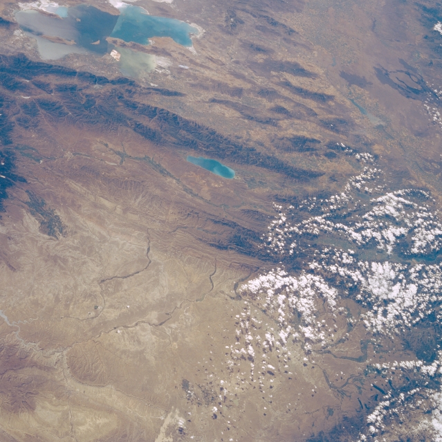 |
| STS51F-042-0038 Great Salt Lake, Great Divide Basin, and Snake River Plain, Utah, Wyoming, and Idaho, U.S.A. August 1985 This west-southwest-looking, low-oblique, panoramic photograph shows portions of northern Utah, southwestern Wyoming, and southeastern Idaho. Several natural features are apparent--the Great Salt Lake in Utah; smaller, elongated Bear Lake; the Bear Lake Range, just above Bear Lake; and the Snake River Plain in Idaho. Visible are dark lava flows in the Snake River Plain and Craters of the Moon National Monument. The bottom half of the photograph shows the western portion of the Great Divide Basin in Wyoming. Clouds cover the southern portions of the Salt River Range and the Wind River Range in Wyoming. |
| Images: | All Available Images Low-Resolution 355k |
|
| Mission: | STS51F |
|
| Roll - Frame: | 42 - 38 |
|
| Geographical Name: | USA-WYOMING |
|
| Features: | GREAT SALT LAKE |
|
| Center Lat x Lon: | 42.5N x 111W |
|
| Film Exposure: | N | N=Normal exposure, U=Under exposed, O=Over exposed, F=out of Focus |
| Percentage of Cloud Cover-CLDP: | 30 |
|
| Camera:: | HB |
|
| Camera Tilt: | 55 | LO=Low Oblique, HO=High Oblique, NV=Near Vertical |
| Camera Focal Length: | 100 |
|
| Nadir to Photo Center Direction: | W | The direction from the nadir to the center point, N=North, S=South, E=East, W=West |
| Stereo?: | N | Y=Yes there is an adjacent picture of the same area, N=No there isn't |
| Orbit Number: | 81 |
|
| Date: | 19850803 | YYYYMMDD |
| Time: | 220441 | GMT HHMMSS |
| Nadir Lat: | 41.4N |
Latitude of suborbital point of spacecraft |
| Nadir Lon: | 107W |
Longitude of suborbital point of spacecraft |
| Sun Azimuth: | 249 | Clockwise angle in degrees from north to the sun measured at the nadir point |
| Space Craft Altitude: | 175 | nautical miles |
| Sun Elevation: | 46 | Angle in degrees between the horizon and the sun, measured at the nadir point |
| Land Views: | RANGE, BASIN |
|
| Water Views: | LAKE |
|
| Atmosphere Views: | |
|
| Man Made Views: | |
|
| City Views: | |
|
Photo is not associated with any sequences | ||
| NASA Home Page |
JSC Home Page |
JSC Digital Image Collection |
Earth Science & Remote Sensing |
|
This service is provided by the International Space Station program and the JSC Earth Science & Remote Sensing Unit, ARES Division, Exploration Integration Science Directorate.

|