Geographic Region: REPUBLIC SOUTH AFRICA
Feature: HARTSWATER IRRIGATION
|
Geographic Region: REPUBLIC SOUTH AFRICA Feature: HARTSWATER IRRIGATION |
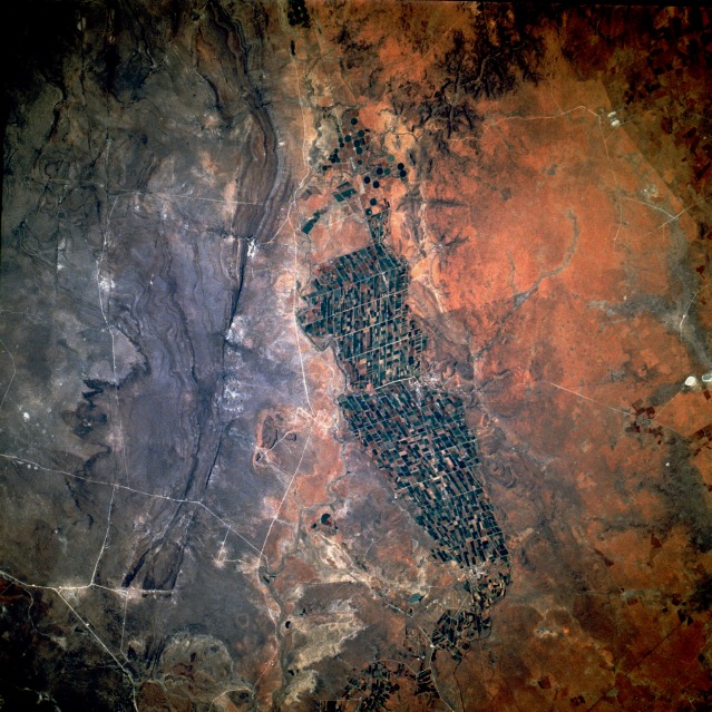 |
| STS41D-044-0030 Irrigated Agriculture, South Africa September 1984 Irrigated agricultural field patterns stand out dramatically against the browns and grays of the semiarid environment in central South Africa. The regimented, systematic cropland fields are outlined by numerous irrigation ditches in this small river valley, which is on a tributary of the Vaal River. This agricultural valley, located about 65 miles (105 kilometers) due north of the city of Kimberley, is approximately 20 miles (32 kilometers) in length north-south and averages about 7 miles (10 kilometers) in width. The circular field patterns north of the main irrigated area indicate center-pivot irrigation technology is also being used to grow crops. The general terrain around this intensively cultivated valley consists of steep-sided river banks, hills, and low escarpments. A major north-south highway, as well as a railroad line, traverse the irrigated farmland. The city of Hartswater sits on the eastern edge of the irrigated fields, approximately midway between the north-south limits of the field patterns. |
| Images: | All Available Images Low-Resolution 163k |
|
| Mission: | STS41D |
|
| Roll - Frame: | 44 - 30 |
|
| Geographical Name: | REPUBLIC SOUTH AFRICA |
|
| Features: | HARTSWATER IRRIGATION |
|
| Center Lat x Lon: | 27.5S x 24.5E |
|
| Film Exposure: | N | N=Normal exposure, U=Under exposed, O=Over exposed, F=out of Focus |
| Percentage of Cloud Cover-CLDP: | 0 |
|
| Camera:: | HB |
|
| Camera Tilt: | 28 | LO=Low Oblique, HO=High Oblique, NV=Near Vertical |
| Camera Focal Length: | 250 |
|
| Nadir to Photo Center Direction: | W | The direction from the nadir to the center point, N=North, S=South, E=East, W=West |
| Stereo?: | N | Y=Yes there is an adjacent picture of the same area, N=No there isn't |
| Orbit Number: | 81 |
|
| Date: | 19840904 | YYYYMMDD |
| Time: | 135905 | GMT HHMMSS |
| Nadir Lat: | 27.8S |
Latitude of suborbital point of spacecraft |
| Nadir Lon: | 25.9E |
Longitude of suborbital point of spacecraft |
| Sun Azimuth: | 96 | Clockwise angle in degrees from north to the sun measured at the nadir point |
| Space Craft Altitude: | 161 | nautical miles |
| Sun Elevation: | 25 | Angle in degrees between the horizon and the sun, measured at the nadir point |
| Land Views: | VALLEY, ESCARPMENT, PLATEAU |
|
| Water Views: | RIVER |
|
| Atmosphere Views: | |
|
| Man Made Views: | AGRICULTURE, PIVOT IRRIGATION |
|
| City Views: | |
|
Photo is not associated with any sequences | ||
| NASA Home Page |
JSC Home Page |
JSC Digital Image Collection |
Earth Science & Remote Sensing |
|
This service is provided by the International Space Station program and the JSC Earth Science & Remote Sensing Unit, ARES Division, Exploration Integration Science Directorate.

|