
Geographic Region: USA-CALIFORNIA
Feature: SALTON SEA, IMPERIAL VALLEY, JOSHUA TREE NATIONAL PARK
|
Geographic Region: USA-CALIFORNIA Feature: SALTON SEA, IMPERIAL VALLEY, JOSHUA TREE NATIONAL PARK |
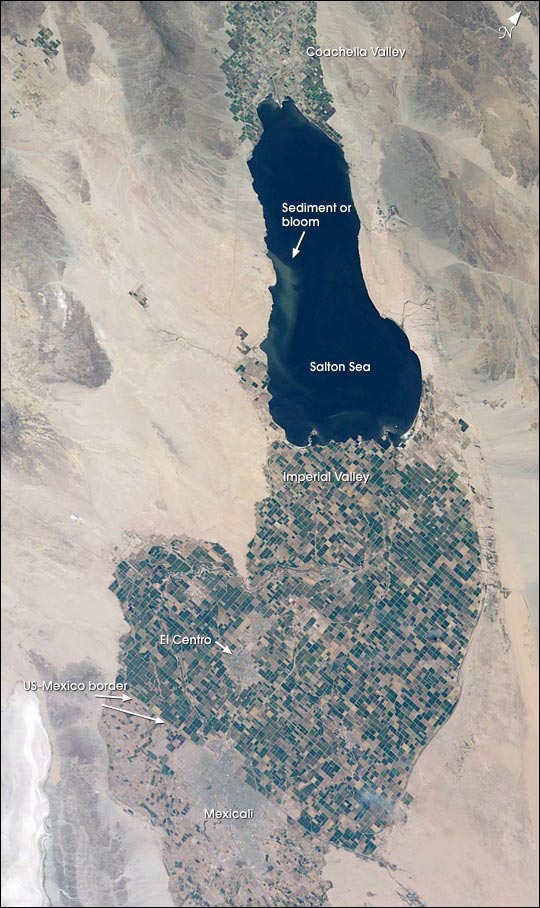 |
| Southern California's Salton Sea is a prominent visual for astronauts. This large lake supports the rich agricultural fields of the Imperial, Coachella and Mexicali Valleys in the California and Mexico desert. The Salton Sea formed by accident in 1905 when an irrigation canal ruptured, allowing the Colorado River to flood the Salton Basin. Today the Sea performs an important function as the sink for agricultural runoff; water levels are maintained by the runoff from the surrounding agricultural valleys. The Salton Sea salinity is high--nearly 1/4 saltier than ocean water--but it remains an important stopover point for migratory water birds, including several endangered species. The region also experiences several environmental problems. The recent increased demands for the limited Colorado River water threatens the amount of water allowed to flow into the Salton Sea. Increased salinity and decreased water levels could trigger several regional environmental crises. The agricultural flow into the Sea includes nutrients and agricultural by-products, increasing the productivity and likelihood of algae blooms. This image shows either a bloom, or suspended sediment (usually highly organic) in the water that has been stirred up by winds. |
| Images: | All Available Images Low-Resolution 107k |
|
| Mission: | STS111 |
|
| Roll - Frame: | E - 5224 |
|
| Geographical Name: | USA-CALIFORNIA |
|
| Features: | SALTON SEA, IMPERIAL VALLEY, JOSHUA TREE NATIONAL PARK |
|
| Center Lat x Lon: | 33.5N x 116W |
|
| Film Exposure: | N=Normal exposure, U=Under exposed, O=Over exposed, F=out of Focus |
|
| Percentage of Cloud Cover-CLDP: | 10 |
|
| Camera:: | E4 |
|
| Camera Tilt: | LO=Low Oblique, HO=High Oblique, NV=Near Vertical |
|
| Camera Focal Length: | 70 |
|
| Nadir to Photo Center Direction: | The direction from the nadir to the center point, N=North, S=South, E=East, W=West |
|
| Stereo?: | Y=Yes there is an adjacent picture of the same area, N=No there isn't |
|
| Orbit Number: | |
|
| Date: | 20020612 | YYYYMMDD |
| Time: | GMT HHMMSS |
|
| Nadir Lat: | N |
Latitude of suborbital point of spacecraft |
| Nadir Lon: | E |
Longitude of suborbital point of spacecraft |
| Sun Azimuth: | Clockwise angle in degrees from north to the sun measured at the nadir point |
|
| Space Craft Altitude: | nautical miles |
|
| Sun Elevation: | Angle in degrees between the horizon and the sun, measured at the nadir point |
|
| Land Views: | DESERT |
|
| Water Views: | LAKE, SEA, SEDIMENT |
|
| Atmosphere Views: | |
|
| Man Made Views: | |
|
| City Views: | |
|
Photo is not associated with any sequences | ||
| NASA Home Page |
JSC Home Page |
JSC Digital Image Collection |
Earth Science & Remote Sensing |
|
This service is provided by the International Space Station program and the JSC Earth Science & Remote Sensing Unit, ARES Division, Exploration Integration Science Directorate.

|