Geographic Region: SPAIN
Feature: STRAIT OF GIBRALTAR, SUNGLINT
|
Geographic Region: SPAIN Feature: STRAIT OF GIBRALTAR, SUNGLINT |
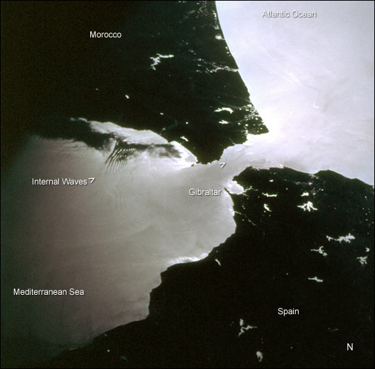 |
| This photograph was taken by the STS-98 astronaut crew as they passed over the western Mediterranean region near sunset on February 19, 2001. Two packets of tidally-generated internal waves are highlighted by sun glinting off the surface waters in the Strait of Gibraltar. The older packet (labeled) contains at least 14 waves, which can be counted like tree rings. A younger group is forming near the middle of the strait (marked by the carat south of Gibraltar). The waves are generated as a diurnal tidal pulse flows over the shallow Camarinal Sill at Gibraltar. The waves flow eastward, refract around coastal features; can be traced for as much as 150 km, and sometimes create interference patterns with refracted waves. Surface water patterns can be observed by astronauts in low-Earth orbit in the sunglint: the sun reflects and is differentially scattered off the water surface. The strength of the reflection is determined by the surfactant layer, which can dampen capillary waves and change the surface texture of the water. Different types of near-surface water structures act to locally concentrate or thin the surfactant layer, which, depending on the instantaneous geometry of the Sun, the Earth and the spacecraft, show up as brighter and darker regions on the water. Although sunglint effectively masks true water color, the sunglint patterns reveal surface water dynamics like eddies, current boundaries and even deeper water features like internal waves that are otherwise invisible. Sunglint also effectively traces land-water boundaries. The bright regions in Spain and Morocco are reservoirs, rivers and lakes. |
| Images: | All Available Images Low-Resolution 37k |
|
| Mission: | STS098 |
|
| Roll - Frame: | 712 - 29 |
|
| Geographical Name: | SPAIN |
|
| Features: | STRAIT OF GIBRALTAR, SUNGLINT |
|
| Center Lat x Lon: | 36.0N x 5.5W |
|
| Film Exposure: | N=Normal exposure, U=Under exposed, O=Over exposed, F=out of Focus |
|
| Percentage of Cloud Cover-CLDP: | 10 |
|
| Camera:: | HB |
|
| Camera Tilt: | 51 | LO=Low Oblique, HO=High Oblique, NV=Near Vertical |
| Camera Focal Length: | 100 |
|
| Nadir to Photo Center Direction: | SW | The direction from the nadir to the center point, N=North, S=South, E=East, W=West |
| Stereo?: | Y=Yes there is an adjacent picture of the same area, N=No there isn't |
|
| Orbit Number: | 168 |
|
| Date: | 20010218 | YYYYMMDD |
| Time: | 144259 | GMT HHMMSS |
| Nadir Lat: | 39.0N |
Latitude of suborbital point of spacecraft |
| Nadir Lon: | 2.7W |
Longitude of suborbital point of spacecraft |
| Sun Azimuth: | 220 | Clockwise angle in degrees from north to the sun measured at the nadir point |
| Space Craft Altitude: | 198 | nautical miles |
| Sun Elevation: | 30 | Angle in degrees between the horizon and the sun, measured at the nadir point |
| Land Views: | |
|
| Water Views: | STRAIT, SUNGLINT |
|
| Atmosphere Views: | |
|
| Man Made Views: | |
|
| City Views: | |
|
Photo is not associated with any sequences | ||
| NASA Home Page |
JSC Home Page |
JSC Digital Image Collection |
Earth Science & Remote Sensing |
|
This service is provided by the International Space Station program and the JSC Earth Science & Remote Sensing Unit, ARES Division, Exploration Integration Science Directorate.

|