Geographic Region: TANZANIA
Feature: MT. KILIMANJARO
|
Geographic Region: TANZANIA Feature: MT. KILIMANJARO |
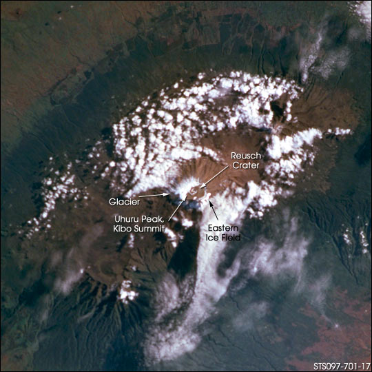 |
| STS097-701-17 Kilimanjaro, Tanzania Kilimanjaro (elevation 5875 m) is a complex of three volcanic peaks in the Kenya branch of the East African rift, just south of the Kenya-Tanzania border. Rift volcanism in this region includes fissure and fault eruptions along the floor of the rift, but the largest volcanoes are at intersections of north-trending rift-valley faults and the ancient, northwest-trending Aswa fault zone. Volcanoes at such intersections are commonly long-lived; Kilimanjaro has erupted episodically for almost a million years, and Reusch crater on the Kibo summit may be only a few hundred years old, as steam and sulfur fumaroles are still active. Kilimanjaro (Kilima Njaro or "shining mountain" in Swahili)is capped by glacial relics of the last ice age. Field studies indicate that most of Kilimanjaro was once covered by much as 100 m of ice and that glaciers extended well down the mountainsides. The most extensive remaining glaciers are on the southern and southwestern flanks. The glaciers and snow cap covered a far greater area ten years prior to the view above. |
| Images: | All Available Images Low-Resolution 65k |
|
| Mission: | STS097 |
|
| Roll - Frame: | 701 - 17 |
|
| Geographical Name: | TANZANIA |
|
| Features: | MT. KILIMANJARO |
|
| Center Lat x Lon: | 3S x 37.5E |
|
| Film Exposure: | N=Normal exposure, U=Under exposed, O=Over exposed, F=out of Focus |
|
| Percentage of Cloud Cover-CLDP: | 50 |
|
| Camera:: | HB |
|
| Camera Tilt: | 20 | LO=Low Oblique, HO=High Oblique, NV=Near Vertical |
| Camera Focal Length: | 250 |
|
| Nadir to Photo Center Direction: | SW | The direction from the nadir to the center point, N=North, S=South, E=East, W=West |
| Stereo?: | Y=Yes there is an adjacent picture of the same area, N=No there isn't |
|
| Orbit Number: | 18 |
|
| Date: | 20001202 | YYYYMMDD |
| Time: | 051311 | GMT HHMMSS |
| Nadir Lat: | 2.1S |
Latitude of suborbital point of spacecraft |
| Nadir Lon: | 38.2E |
Longitude of suborbital point of spacecraft |
| Sun Azimuth: | 114 | Clockwise angle in degrees from north to the sun measured at the nadir point |
| Space Craft Altitude: | 190 | nautical miles |
| Sun Elevation: | 28 | Angle in degrees between the horizon and the sun, measured at the nadir point |
| Land Views: | CRATER, FAULT, MOUNTAIN, RIFT, VALLEY |
|
| Water Views: | ICE |
|
| Atmosphere Views: | |
|
| Man Made Views: | |
|
| City Views: | |
|
Photo is not associated with any sequences | ||
| NASA Home Page |
JSC Home Page |
JSC Digital Image Collection |
Earth Science & Remote Sensing |
|
This service is provided by the International Space Station program and the JSC Earth Science & Remote Sensing Unit, ARES Division, Exploration Integration Science Directorate.

|