
Geographic Region: CHINA
Feature: TIEN SHAN, AGR., URUMQI
|
Geographic Region: CHINA Feature: TIEN SHAN, AGR., URUMQI |
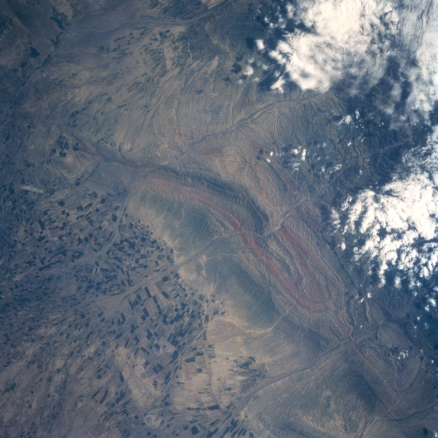 |
| STS091-719-004 Dzungarian Basin, China June 1998 The northern foothills of the Tien Shan (mountains) slope into the southern margin of the arid Dzungarian Basin in northwest China. The eroded material from the higher mountains to the south, have produced large, fertile, alluvial fans that are being used extensively for irrigated farming (alternating and angular color patterns). Several intermittently flowing streams have cut perpendicular valleys through the mountain ridgeline (linear geologic feature) that extends diagonally through the center of the image. The Chinese city of Urumqi is located near the upper left corner of the image. An airport runway (light-colored linear feature near the left middle edge of the frame) is visible northwest of the city. |
| Images: | All Available Images Low-Resolution 369k |
|
| Mission: | STS091 |
|
| Roll - Frame: | 719 - 4 |
|
| Geographical Name: | CHINA |
|
| Features: | TIEN SHAN, AGR., URUMQI |
|
| Center Lat x Lon: | 43.6N x 87.8E |
|
| Film Exposure: | N | N=Normal exposure, U=Under exposed, O=Over exposed, F=out of Focus |
| Percentage of Cloud Cover-CLDP: | 10 |
|
| Camera:: | HB |
|
| Camera Tilt: | 7 | LO=Low Oblique, HO=High Oblique, NV=Near Vertical |
| Camera Focal Length: | 250 |
|
| Nadir to Photo Center Direction: | SW | The direction from the nadir to the center point, N=North, S=South, E=East, W=West |
| Stereo?: | Y | Y=Yes there is an adjacent picture of the same area, N=No there isn't |
| Orbit Number: | 149 |
|
| Date: | 19980612 | YYYYMMDD |
| Time: | 084523 | GMT HHMMSS |
| Nadir Lat: | 43.8N |
Latitude of suborbital point of spacecraft |
| Nadir Lon: | 88.1E |
Longitude of suborbital point of spacecraft |
| Sun Azimuth: | 251 | Clockwise angle in degrees from north to the sun measured at the nadir point |
| Space Craft Altitude: | 186 | nautical miles |
| Sun Elevation: | 52 | Angle in degrees between the horizon and the sun, measured at the nadir point |
| Land Views: | MOUNTAIN, ALLUVIAL FAN, BASIN |
|
| Water Views: | |
|
| Atmosphere Views: | |
|
| Man Made Views: | AGRICULTURE, AIRPORT |
|
| City Views: | |
|
Photo is not associated with any sequences | ||
| NASA Home Page |
JSC Home Page |
JSC Digital Image Collection |
Earth Science & Remote Sensing |
|
This service is provided by the International Space Station program and the JSC Earth Science & Remote Sensing Unit, ARES Division, Exploration Integration Science Directorate.

|