Geographic Region: BANGLADESH
Feature: GANGES RIVER
|
Geographic Region: BANGLADESH Feature: GANGES RIVER |
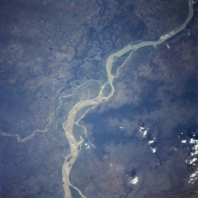 |
| STS091-702-023 Ganges River, India June 1998 A small section of the meandering Ganges River (ribbon-like, light-colored feature), the major river of the Indian subcontinent, skirts along the northern edge of the Rajmahal Hills (darker landscape, bottom center). These brownish-looking, vegetated hills rise between 500 feet (150 meters) to over 1000 feet (300 meters) above the surrounding plains. The Hindu people believe that the Ganges River is the most sacred river in the world. The river's broad floodplain contains many interconnected channels. The south draining, meandering Mahananda River (smaller, light-colored line-bottom left) converges with the main channel of the Ganges near the center of the image. Downstream from the confluence of these two rivers a railroad bridge (straight line crossing the Ganges) and a drainage canal (thin, straight, light-colored line) can be identified. The bridge crossing is located approximately 5 miles (8 km) northwest of the Indian-Bangladesh border. |
| Images: | All Available Images Low-Resolution 352k |
|
| Mission: | STS091 |
|
| Roll - Frame: | 702 - 23 |
|
| Geographical Name: | BANGLADESH |
|
| Features: | GANGES RIVER |
|
| Center Lat x Lon: | 24.0N x 89.0E |
|
| Film Exposure: | O | N=Normal exposure, U=Under exposed, O=Over exposed, F=out of Focus |
| Percentage of Cloud Cover-CLDP: | 5 |
|
| Camera:: | HB |
|
| Camera Tilt: | 25 | LO=Low Oblique, HO=High Oblique, NV=Near Vertical |
| Camera Focal Length: | 250 |
|
| Nadir to Photo Center Direction: | SW | The direction from the nadir to the center point, N=North, S=South, E=East, W=West |
| Stereo?: | N | Y=Yes there is an adjacent picture of the same area, N=No there isn't |
| Orbit Number: | 40 |
|
| Date: | 19980605 | YYYYMMDD |
| Time: | 093755 | GMT HHMMSS |
| Nadir Lat: | 25.2N |
Latitude of suborbital point of spacecraft |
| Nadir Lon: | 90.0E |
Longitude of suborbital point of spacecraft |
| Sun Azimuth: | 279 | Clockwise angle in degrees from north to the sun measured at the nadir point |
| Space Craft Altitude: | 199 | nautical miles |
| Sun Elevation: | 40 | Angle in degrees between the horizon and the sun, measured at the nadir point |
| Land Views: | HILL |
|
| Water Views: | RIVER |
|
| Atmosphere Views: | |
|
| Man Made Views: | |
|
| City Views: | |
|
Photo is not associated with any sequences | ||
| NASA Home Page |
JSC Home Page |
JSC Digital Image Collection |
Earth Science & Remote Sensing |
|
This service is provided by the International Space Station program and the JSC Earth Science & Remote Sensing Unit, ARES Division, Exploration Integration Science Directorate.

|