Geographic Region: GREECE
Feature: ATHENS, AIYINA ISLAND
|
Geographic Region: GREECE Feature: ATHENS, AIYINA ISLAND |
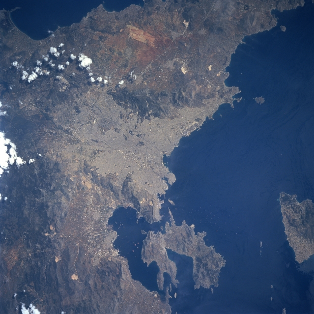 |
| STS090-759-49 Athens, Greece April 1998 Athens, the capital and largest city in Greece (center of the image), and one of the world's most historical and beautiful cities, can be seen in this northeast looking view. Named for Athena, the goddess of wisdom, Athens is the hub of Greek political, industrial, and cultural life. Together, Athens and its port city of Piraeus, account for nearly 45% of Greece's industrial output. The city is located on a plain cut by limestone ridges. On the green hill of the Acropolis, the light rectangular areas of the Parthenon and the Agora are easily visible. Most all the buildings in the city are constructed of white marble. The Saronic Gulf, an inlet to the Aegean Sea, lies a few miles (km) southwest of the city. The climate of Athens is temperate and dry. The more reflective clear area near the right center of the image is the Spata Airfield. Aiyina Island is visible near the bottom right of the image. |
| Images: | All Available Images Low-Resolution 329k |
|
| Mission: | STS090 |
|
| Roll - Frame: | 759 - 49 |
|
| Geographical Name: | GREECE |
|
| Features: | ATHENS, AIYINA ISLAND |
|
| Center Lat x Lon: | 38.0N x 23.5E |
|
| Film Exposure: | N | N=Normal exposure, U=Under exposed, O=Over exposed, F=out of Focus |
| Percentage of Cloud Cover-CLDP: | 5 |
|
| Camera:: | HB |
|
| Camera Tilt: | 13 | LO=Low Oblique, HO=High Oblique, NV=Near Vertical |
| Camera Focal Length: | 250 |
|
| Nadir to Photo Center Direction: | E | The direction from the nadir to the center point, N=North, S=South, E=East, W=West |
| Stereo?: | Y | Y=Yes there is an adjacent picture of the same area, N=No there isn't |
| Orbit Number: | 172 |
|
| Date: | 19980428 | YYYYMMDD |
| Time: | 102254 | GMT HHMMSS |
| Nadir Lat: | 37.9N |
Latitude of suborbital point of spacecraft |
| Nadir Lon: | 23.0E |
Longitude of suborbital point of spacecraft |
| Sun Azimuth: | 178 | Clockwise angle in degrees from north to the sun measured at the nadir point |
| Space Craft Altitude: | 131 | nautical miles |
| Sun Elevation: | 66 | Angle in degrees between the horizon and the sun, measured at the nadir point |
| Land Views: | COAST, MOUNTAIN, PLAIN |
|
| Water Views: | GULF |
|
| Atmosphere Views: | |
|
| Man Made Views: | URBAN AREA, AIRPORT |
|
| City Views: | ATHENS |
|
Photo is not associated with any sequences | ||
| NASA Home Page |
JSC Home Page |
JSC Digital Image Collection |
Earth Science & Remote Sensing |
|
This service is provided by the International Space Station program and the JSC Earth Science & Remote Sensing Unit, ARES Division, Exploration Integration Science Directorate.

|