
Geographic Region: USA-CALIFORNIA
Feature: EL CENTRO, MEXICALI,AGR.
|
Geographic Region: USA-CALIFORNIA Feature: EL CENTRO, MEXICALI,AGR. |
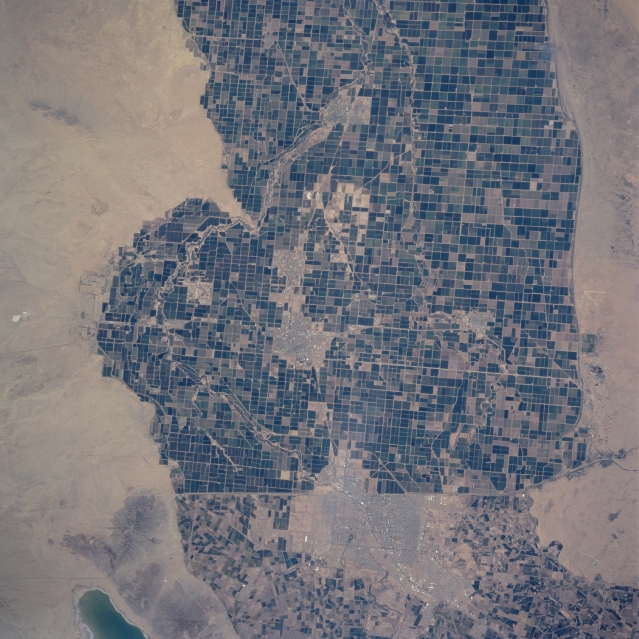 |
| STS090-758-022 Imperial Valley, California, USA April 1997 The border between the United States and Mexico consists of intensively cultivated field patterns. This area is the Imperial Valley of south central California. Although the extensive array of large productive fields is located in a desert environment, the image indicates where effective irrigation (from water provided by the Colorado River) has turned this normally arid landscape into a highly productive agricultural region. The only disruptions to the cultivated landscape are a few cities on the U. S. side of the border (El Centro, Calexico, Brawley, and Holtville) and the much large city of Mexicali on the Mexican side of the border. Notice that there is an obvious difference in land management and ownership on the two sides of the border. Several canals, mainly the Westside Main Canal (white, winding, feature), are used for irrigation purposes and can be traced across the plain of the Imperial Valley. The greenish looking feature in the southwest corner of the image is the northern tip of Laguna Salada. |
| Images: | All Available Images Low-Resolution 357k |
|
| Mission: | STS090 |
|
| Roll - Frame: | 758 - 22 |
|
| Geographical Name: | USA-CALIFORNIA |
|
| Features: | EL CENTRO, MEXICALI,AGR. |
|
| Center Lat x Lon: | 33.0N x 115.5W |
|
| Film Exposure: | N | N=Normal exposure, U=Under exposed, O=Over exposed, F=out of Focus |
| Percentage of Cloud Cover-CLDP: | 0 |
|
| Camera:: | HB |
|
| Camera Tilt: | 22 | LO=Low Oblique, HO=High Oblique, NV=Near Vertical |
| Camera Focal Length: | 250 |
|
| Nadir to Photo Center Direction: | NW | The direction from the nadir to the center point, N=North, S=South, E=East, W=West |
| Stereo?: | N | Y=Yes there is an adjacent picture of the same area, N=No there isn't |
| Orbit Number: | 50 |
|
| Date: | 19980420 | YYYYMMDD |
| Time: | 194547 | GMT HHMMSS |
| Nadir Lat: | 32.6N |
Latitude of suborbital point of spacecraft |
| Nadir Lon: | 114.7W |
Longitude of suborbital point of spacecraft |
| Sun Azimuth: | 186 | Clockwise angle in degrees from north to the sun measured at the nadir point |
| Space Craft Altitude: | 136 | nautical miles |
| Sun Elevation: | 69 | Angle in degrees between the horizon and the sun, measured at the nadir point |
| Land Views: | DESERT |
|
| Water Views: | CANAL, LAGOON |
|
| Atmosphere Views: | |
|
| Man Made Views: | AGRICULTURE, URBAN AREA, HIGHWAY |
|
| City Views: | |
|
Photo is not associated with any sequences | ||
| NASA Home Page |
JSC Home Page |
JSC Digital Image Collection |
Earth Science & Remote Sensing |
|
This service is provided by the International Space Station program and the JSC Earth Science & Remote Sensing Unit, ARES Division, Exploration Integration Science Directorate.

|