
Geographic Region: USA-CALIFORNIA
Feature: FRESNO, SAN JOAQUIN V.
|
Geographic Region: USA-CALIFORNIA Feature: FRESNO, SAN JOAQUIN V. |
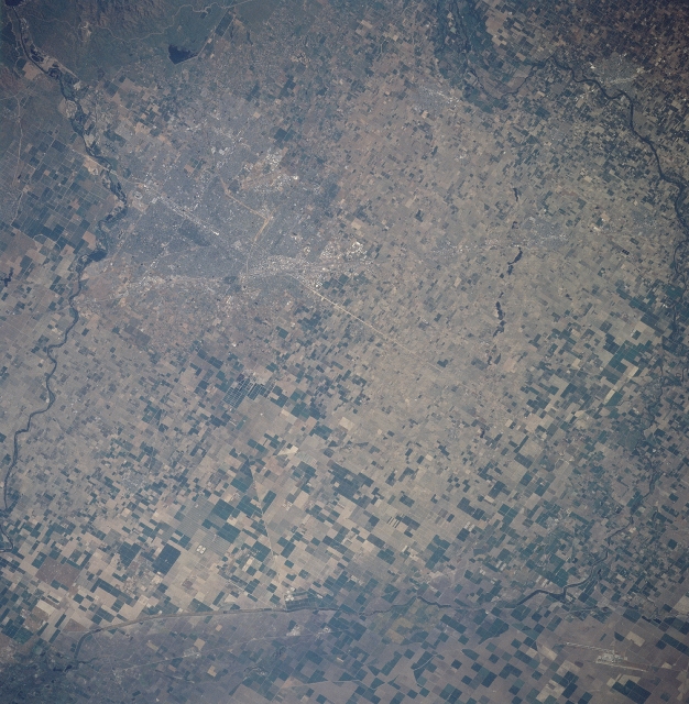 |
| STS090-734-011 Fresno Area, California, USA April 1998 The gridded street pattern of Fresno and Clovis (smaller community north, northeast of Fresno) is discernible near the north corner of the image. California Highway 41 (light colored line) is visible as it runs north and south through the center of Fresno. A section of the San Joaquin River (dark, meandering feature-bottom) is visible as it flows westerly through the central section of the San Joaquin Valley. Although the valley has a desert environment, an elaborate irrigation system enables the dry soils to produce fruits, vegetables, and cereal grains. Notice that the cultivated fields (mainly rectangular in shape) increase in size west and southwest of Fresno. The dark, linear feature that somewhat parallels the right edge of the picture is part of the Delta Mendota Canal that provides water for the intensively cultivated landscape. The two highly reflective offset lines in the south corner of the scene are runways at Lemoore Naval Air Station. |
| Images: | All Available Images Low-Resolution 369k |
|
| Mission: | STS090 |
|
| Roll - Frame: | 734 - 11 |
|
| Geographical Name: | USA-CALIFORNIA |
|
| Features: | FRESNO, SAN JOAQUIN V. |
|
| Center Lat x Lon: | 36.5N x 120W |
|
| Film Exposure: | N | N=Normal exposure, U=Under exposed, O=Over exposed, F=out of Focus |
| Percentage of Cloud Cover-CLDP: | 0 |
|
| Camera:: | HB |
|
| Camera Tilt: | 32 | LO=Low Oblique, HO=High Oblique, NV=Near Vertical |
| Camera Focal Length: | 250 |
|
| Nadir to Photo Center Direction: | W | The direction from the nadir to the center point, N=North, S=South, E=East, W=West |
| Stereo?: | Y | Y=Yes there is an adjacent picture of the same area, N=No there isn't |
| Orbit Number: | 208 |
|
| Date: | 19980430 | YYYYMMDD |
| Time: | 160232 | GMT HHMMSS |
| Nadir Lat: | 37.0N |
Latitude of suborbital point of spacecraft |
| Nadir Lon: | 118.7W |
Longitude of suborbital point of spacecraft |
| Sun Azimuth: | 98 | Clockwise angle in degrees from north to the sun measured at the nadir point |
| Space Craft Altitude: | 133 | nautical miles |
| Sun Elevation: | 35 | Angle in degrees between the horizon and the sun, measured at the nadir point |
| Land Views: | |
|
| Water Views: | CANAL, RIVER |
|
| Atmosphere Views: | |
|
| Man Made Views: | HIGHWAY, AIRPORT, AGRICULTURE |
|
| City Views: | |
|
Photo is not associated with any sequences | ||
| NASA Home Page |
JSC Home Page |
JSC Digital Image Collection |
Earth Science & Remote Sensing |
|
This service is provided by the International Space Station program and the JSC Earth Science & Remote Sensing Unit, ARES Division, Exploration Integration Science Directorate.

|