Geographic Region: ARGENTINA
Feature: PARANA RIVER
|
Geographic Region: ARGENTINA Feature: PARANA RIVER |
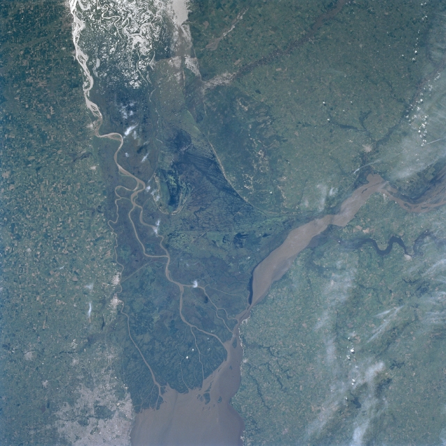 |
| STS089-709-055 Parana River Delta, Argentina January 1997 The Parana River is considered to be one of South America's three great rivers. It has built a large delta complex at the northwest end of the Rio de la Plata estuary. Several sediment laden distributary channels are visible as they wind through the dense vegetation of the broad swath of dark-looking swampland that is the delta area. The linear features near the center of the image in the mouth of the delta are canals. The flat, intensely cultivated landscape that surrounds the large delta includes extensive grasslands. A variety of crops, such as, alfalfa, wheat, sorghum, corn (maize), and sunflowers are grown throughout this humid temperate climate. The bright area along the top of the picture is the sun's reflection off open water. It is called sunglint or sun glitter. The sunglint enables the viewer to see the complexity of the drainage pattern, the extent of wetlands, and the flood-plain boundaries for this part of the Parana River. The lighter colored area along the lower left margin of the picture is western Buenos Aires. The muddy-looking Uruguay River also flows into the northwest corner of the Rio de la Plata. |
| Images: | All Available Images Low-Resolution 346k |
|
| Mission: | STS089 |
|
| Roll - Frame: | 709 - 55 |
|
| Geographical Name: | ARGENTINA |
|
| Features: | PARANA RIVER |
|
| Center Lat x Lon: | 34S x 58.5W |
|
| Film Exposure: | N | N=Normal exposure, U=Under exposed, O=Over exposed, F=out of Focus |
| Percentage of Cloud Cover-CLDP: | 5 |
|
| Camera:: | HB |
|
| Camera Tilt: | 8 | LO=Low Oblique, HO=High Oblique, NV=Near Vertical |
| Camera Focal Length: | 100 |
|
| Nadir to Photo Center Direction: | SW | The direction from the nadir to the center point, N=North, S=South, E=East, W=West |
| Stereo?: | N | Y=Yes there is an adjacent picture of the same area, N=No there isn't |
| Orbit Number: | 120 |
|
| Date: | 19980130 | YYYYMMDD |
| Time: | 183000 | GMT HHMMSS |
| Nadir Lat: | 33.8S |
Latitude of suborbital point of spacecraft |
| Nadir Lon: | 58.1W |
Longitude of suborbital point of spacecraft |
| Sun Azimuth: | 287 | Clockwise angle in degrees from north to the sun measured at the nadir point |
| Space Craft Altitude: | 197 | nautical miles |
| Sun Elevation: | 54 | Angle in degrees between the horizon and the sun, measured at the nadir point |
| Land Views: | PLAIN |
|
| Water Views: | RIVER, DELTA, SEDIMENT, SUNGLINT |
|
| Atmosphere Views: | |
|
| Man Made Views: | |
|
| City Views: | |
|
Photo is not associated with any sequences | ||
| NASA Home Page |
JSC Home Page |
JSC Digital Image Collection |
Earth Science & Remote Sensing |
|
This service is provided by the International Space Station program and the JSC Earth Science & Remote Sensing Unit, ARES Division, Exploration Integration Science Directorate.

|