Geographic Region: NETHERLANDS
Feature: ROTTERDAM, AMSTERDAM
|
Geographic Region: NETHERLANDS Feature: ROTTERDAM, AMSTERDAM |
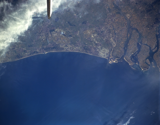 |
| STS085-506-98 The Hague, Rotterdam, Netherlands August 1997 The delta of the Rhine River (right center) and the locations of the cities of The Hague and Rotterdam can be identified in this near-nadir view. The Hague is located on the coast of the North Sea northeast (left) of the Rhine River Delta. The city is the seat of the government of the kingdom of the Netherlands. Although, The Hague has some industries (clothing, metal goods, printed materials, and food products), the city's economy revolves around government administration. The International Court of Justice is located in The Hague. Rotterdam is located on the Nievwe Maas River, a distributary of the Rhine River, several miles (km) inland from the North Sea. Rotterdam is the major foreign-trade center in the Netherlands and boasts one of the world's major seaports. The city has shipyards, oil refineries, automobile assembly plants, and factories that manufacture electronic equipment and clothing. Agricultural field patterns are visible throughout the scene, but are especially noted on the islands in the delta area. |
| Images: | All Available Images Low-Resolution 222k |
|
| Mission: | STS085 |
|
| Roll - Frame: | 506 - 98 |
|
| Geographical Name: | NETHERLANDS |
|
| Features: | ROTTERDAM, AMSTERDAM |
|
| Center Lat x Lon: | 52.0N x 4.0E |
|
| Film Exposure: | N | N=Normal exposure, U=Under exposed, O=Over exposed, F=out of Focus |
| Percentage of Cloud Cover-CLDP: | 20 |
|
| Camera:: | LH |
|
| Camera Tilt: | 35 | LO=Low Oblique, HO=High Oblique, NV=Near Vertical |
| Camera Focal Length: | 250 |
|
| Nadir to Photo Center Direction: | W | The direction from the nadir to the center point, N=North, S=South, E=East, W=West |
| Stereo?: | N | Y=Yes there is an adjacent picture of the same area, N=No there isn't |
| Orbit Number: | 80 |
|
| Date: | 19970812 | YYYYMMDD |
| Time: | 140342 | GMT HHMMSS |
| Nadir Lat: | 52.0N |
Latitude of suborbital point of spacecraft |
| Nadir Lon: | 5.8E |
Longitude of suborbital point of spacecraft |
| Sun Azimuth: | 231 | Clockwise angle in degrees from north to the sun measured at the nadir point |
| Space Craft Altitude: | 157 | nautical miles |
| Sun Elevation: | 43 | Angle in degrees between the horizon and the sun, measured at the nadir point |
| Land Views: | COAST, PLAIN |
|
| Water Views: | RIVER, DELTA |
|
| Atmosphere Views: | |
|
| Man Made Views: | URBAN AREA |
|
| City Views: | |
|
Photo is not associated with any sequences | ||
| NASA Home Page |
JSC Home Page |
JSC Digital Image Collection |
Earth Science & Remote Sensing |
|
This service is provided by the International Space Station program and the JSC Earth Science & Remote Sensing Unit, ARES Division, Exploration Integration Science Directorate.

|