Geographic Region: PERU
Feature: COROPUNA VOLCANO
|
Geographic Region: PERU Feature: COROPUNA VOLCANO |
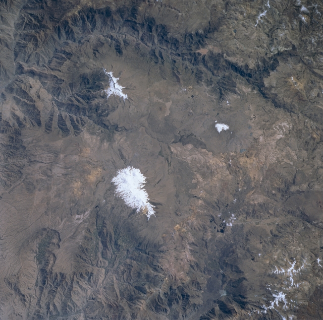 |
| STS084-708-025 Coropuna and Soliman Volcanoes, Peru May 1997 This image shows two magnificent, snow-covered stratovolcanoes located in the Andes Mountains of southern Peru. Just to the left of center lies the 21080 foot (6419 meters) Coropuna Volcano. To the west (above) sits Solimana with at an altitude of 20069 feet (6121 meters). Both have been dormant for the past 100,000 years. To the west (top center and top left of the image) is the deep canyon of the Colohuasi River, which merges with the Ocona River (upper left). As the Andes have continued to rise, these rivers, which flow into the Pacific Ocean, have kept pace by eroding deep canyons and valleys. |
| Images: | All Available Images Low-Resolution 339k |
|
| Mission: | STS084 |
|
| Roll - Frame: | 708 - 25 |
|
| Geographical Name: | PERU |
|
| Features: | COROPUNA VOLCANO |
|
| Center Lat x Lon: | 16S x 72W |
|
| Film Exposure: | N | N=Normal exposure, U=Under exposed, O=Over exposed, F=out of Focus |
| Percentage of Cloud Cover-CLDP: | 0 |
|
| Camera:: | HB |
|
| Camera Tilt: | 16 | LO=Low Oblique, HO=High Oblique, NV=Near Vertical |
| Camera Focal Length: | 250 |
|
| Nadir to Photo Center Direction: | N | The direction from the nadir to the center point, N=North, S=South, E=East, W=West |
| Stereo?: | Y | Y=Yes there is an adjacent picture of the same area, N=No there isn't |
| Orbit Number: | 100 |
|
| Date: | 19970521 | YYYYMMDD |
| Time: | 162206 | GMT HHMMSS |
| Nadir Lat: | 17S |
Latitude of suborbital point of spacecraft |
| Nadir Lon: | 72W |
Longitude of suborbital point of spacecraft |
| Sun Azimuth: | 9 | Clockwise angle in degrees from north to the sun measured at the nadir point |
| Space Craft Altitude: | 213 | nautical miles |
| Sun Elevation: | 52 | Angle in degrees between the horizon and the sun, measured at the nadir point |
| Land Views: | VOLCANO, GLACIER, VALLEY, PLATEAU |
|
| Water Views: | RIVER |
|
| Atmosphere Views: | |
|
| Man Made Views: | |
|
| City Views: | |
|
Photo is not associated with any sequences | ||
| NASA Home Page |
JSC Home Page |
JSC Digital Image Collection |
Earth Science & Remote Sensing |
|
This service is provided by the International Space Station program and the JSC Earth Science & Remote Sensing Unit, ARES Division, Exploration Integration Science Directorate.

|