Geographic Region: SICILY
Feature: MOUNT ETNA VOLCANO
|
Geographic Region: SICILY Feature: MOUNT ETNA VOLCANO |
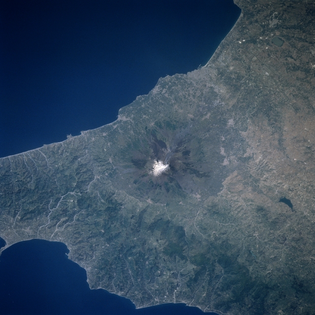 |
| STS084-702-033 Mt. Etna, Sicily, Italy May 1997 The snow capped, multi-cratered summit (white feature) of Mt. Etna, located near the east coast of Sicily is visible in the center of the image. Because of the close proximity of the numerous communities around the base of this still active volcano, Mt. Etna is one of the most studied and monitored volcanoes in the world. The coastal city of Catania, estimated population 350000, is barely discernible at the southern base of Mt. Etna. The radial drainage pattern off of the flanks of this shield volcano is accentuated by recent lava flows (variety of colors on the flanks) with the older flows covered with vegetation (darkest features). There are also areas of dense vegetation (darker features) on the low mountain range northwest of Mt. Etna. The small, isolated, dark feature west of the volcano is a reservoir that is located on one of the tributary streams of the Simeto River, which empties into the small Catania Gulf (south of Catania). Many short-flowing stream channels that drain northward from the mountainous terrain into the Tyrrhenian Sea are observed. |
| Images: | All Available Images Low-Resolution 310k |
|
| Mission: | STS084 |
|
| Roll - Frame: | 702 - 33 |
|
| Geographical Name: | SICILY |
|
| Features: | MOUNT ETNA VOLCANO |
|
| Center Lat x Lon: | 38.0N x 15.0E |
|
| Film Exposure: | N | N=Normal exposure, U=Under exposed, O=Over exposed, F=out of Focus |
| Percentage of Cloud Cover-CLDP: | 0 |
|
| Camera:: | HB |
|
| Camera Tilt: | LO | LO=Low Oblique, HO=High Oblique, NV=Near Vertical |
| Camera Focal Length: | 250 |
|
| Nadir to Photo Center Direction: | The direction from the nadir to the center point, N=North, S=South, E=East, W=West |
|
| Stereo?: | N | Y=Yes there is an adjacent picture of the same area, N=No there isn't |
| Orbit Number: | |
|
| Date: | 199705__ | YYYYMMDD |
| Time: | GMT HHMMSS |
|
| Nadir Lat: | N |
Latitude of suborbital point of spacecraft |
| Nadir Lon: | E |
Longitude of suborbital point of spacecraft |
| Sun Azimuth: | Clockwise angle in degrees from north to the sun measured at the nadir point |
|
| Space Craft Altitude: | nautical miles |
|
| Sun Elevation: | Angle in degrees between the horizon and the sun, measured at the nadir point |
|
| Land Views: | VOLCANO |
|
| Water Views: | |
|
| Atmosphere Views: | |
|
| Man Made Views: | |
|
| City Views: | |
|
Photo is not associated with any sequences | ||
| NASA Home Page |
JSC Home Page |
JSC Digital Image Collection |
Earth Science & Remote Sensing |
|
This service is provided by the International Space Station program and the JSC Earth Science & Remote Sensing Unit, ARES Division, Exploration Integration Science Directorate.

|