Geographic Region: COSTA RICA
Feature: ARENAL VOLCANO
|
Geographic Region: COSTA RICA Feature: ARENAL VOLCANO |
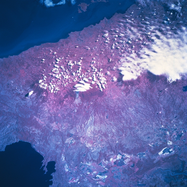 |
| STS081-742-027 Guanacaste Mountains, Costa Rica January 1997 The color infrared image helps to identify three major volcanoes that are part of the Guanacaste Mountains (volcanic range of mountains) in northwest Costa Rica. With many of the volcanic summits being covered by clouds, the deep red colors of the heavily forested slopes of the volcanoes line up in a northwest to southeast alignment. From left to right across the picture the names of the volcanoes are Orosi, Rincon de la Vieja (center of image), and Miravalles. The western flanks of these volcanoes exhibit a severely eroded landscape that grades into the Tempisque River Basin, located southwest of the mountains. This basin is an extensive fertile plain, but during the wet season the Tempisque River can inundate its floodplain and adjacent low-lying terrain. As the river approaches the Gulf of Nicoya, saline lagoons and swamplands increase, forming extensive wetlands. On higher elevations within the Tempisque Basin large field patterns, consisting of ranches and plantations are visible near the bottom of the picture. The darker feature at the top of the picture is the southern end of Lake Nicaragua and the dark feature in the lower left corner of the image is the Gulf of Papagayo. |
| Images: | All Available Images Low-Resolution 376k |
|
| Mission: | STS081 |
|
| Roll - Frame: | 742 - 27 |
|
| Geographical Name: | COSTA RICA |
|
| Features: | ARENAL VOLCANO |
|
| Center Lat x Lon: | 10.5N x 84.5W |
|
| Film Exposure: | N | N=Normal exposure, U=Under exposed, O=Over exposed, F=out of Focus |
| Percentage of Cloud Cover-CLDP: | 20 |
|
| Camera:: | HB |
|
| Camera Tilt: | 35 | LO=Low Oblique, HO=High Oblique, NV=Near Vertical |
| Camera Focal Length: | 250 |
|
| Nadir to Photo Center Direction: | NE | The direction from the nadir to the center point, N=North, S=South, E=East, W=West |
| Stereo?: | Y | Y=Yes there is an adjacent picture of the same area, N=No there isn't |
| Orbit Number: | 131 |
|
| Date: | 19970120 | YYYYMMDD |
| Time: | 162549 | GMT HHMMSS |
| Nadir Lat: | 9.3N |
Latitude of suborbital point of spacecraft |
| Nadir Lon: | 86.4W |
Longitude of suborbital point of spacecraft |
| Sun Azimuth: | 143 | Clockwise angle in degrees from north to the sun measured at the nadir point |
| Space Craft Altitude: | 193 | nautical miles |
| Sun Elevation: | 53 | Angle in degrees between the horizon and the sun, measured at the nadir point |
| Land Views: | MOUNTAIN, VOLCANO, VALLEY |
|
| Water Views: | RIVER |
|
| Atmosphere Views: | |
|
| Man Made Views: | AGRICULTURE |
|
| City Views: | |
|
Photo is not associated with any sequences | ||
| NASA Home Page |
JSC Home Page |
JSC Digital Image Collection |
Earth Science & Remote Sensing |
|
This service is provided by the International Space Station program and the JSC Earth Science & Remote Sensing Unit, ARES Division, Exploration Integration Science Directorate.

|