Geographic Region: NICARAGUA
Feature: GULF OF FONSECA
|
Geographic Region: NICARAGUA Feature: GULF OF FONSECA |
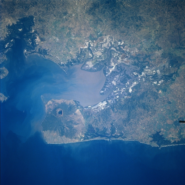 |
| STS081-728-058 Coseguina Volcano, Nicaragua January 1997 This near-nadir view shows the Gulf of Fonseca and Coseguina Volcano in northwest Nicaragua. Coseguina is a basaltic shield volcano with a large central collapsed crater that contains a lake. Coseguina has also been referred too by some volcanologists as a stratovolcano. The volcano has an elevation of 2777 feet (847 meters). The crater is about 1.2 miles (2 km) by 1.5 miles (2.5 km) in diameter and is 1640 feet (500 meters) deep. The crater of Coseguina Volcano was formed during an explosive eruption that occurred on January 22, 1835. Ash and pumice from the eruption covered a large area of Central America and Mexico depositing ash as far as Mexico City, some 869 miles (1400 km) to the north, and the island of Jamaica, some 800 miles (1300 km) to the east. The volcanoes eruption cloud blocked out the sun in a 93-mile (150 km) wide radius. Coseguina erupted again explosively in 1852 producing lava flows. The last recorded eruption was in 1859. The lake seen in the crater began to form in 1938. |
| Images: | All Available Images Low-Resolution 353k |
|
| Mission: | STS081 |
|
| Roll - Frame: | 728 - 58 |
|
| Geographical Name: | NICARAGUA |
|
| Features: | GULF OF FONSECA |
|
| Center Lat x Lon: | 13.0N x 87.5W |
|
| Film Exposure: | N | N=Normal exposure, U=Under exposed, O=Over exposed, F=out of Focus |
| Percentage of Cloud Cover-CLDP: | 0 |
|
| Camera:: | HB |
|
| Camera Tilt: | 23 | LO=Low Oblique, HO=High Oblique, NV=Near Vertical |
| Camera Focal Length: | 250 |
|
| Nadir to Photo Center Direction: | NE | The direction from the nadir to the center point, N=North, S=South, E=East, W=West |
| Stereo?: | Y | Y=Yes there is an adjacent picture of the same area, N=No there isn't |
| Orbit Number: | 131 |
|
| Date: | 19970120 | YYYYMMDD |
| Time: | 162454 | GMT HHMMSS |
| Nadir Lat: | 12.0N |
Latitude of suborbital point of spacecraft |
| Nadir Lon: | 88.4W |
Longitude of suborbital point of spacecraft |
| Sun Azimuth: | 142 | Clockwise angle in degrees from north to the sun measured at the nadir point |
| Space Craft Altitude: | 192 | nautical miles |
| Sun Elevation: | 50 | Angle in degrees between the horizon and the sun, measured at the nadir point |
| Land Views: | VOLCANO, CRATER, FOREST |
|
| Water Views: | GULF, SEDIMENT, SWAMP |
|
| Atmosphere Views: | |
|
| Man Made Views: | |
|
| City Views: | |
|
Photo is not associated with any sequences | ||
| NASA Home Page |
JSC Home Page |
JSC Digital Image Collection |
Earth Science & Remote Sensing |
|
This service is provided by the International Space Station program and the JSC Earth Science & Remote Sensing Unit, ARES Division, Exploration Integration Science Directorate.

|