Geographic Region: TURKEY
Feature: ANTALYA, MTS., LAKES
|
Geographic Region: TURKEY Feature: ANTALYA, MTS., LAKES |
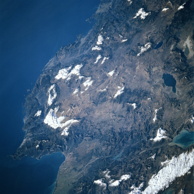 |
| STS081-727-089 Bey Mountains, Antalya, Turkey January 1997 The rugged landscape of southwestern Turkey can be seen in this west-looking view. The ancient coastal city of Antalya, founded in 150 BC, is visible in the lower left portion of the image. Located on the Gulf of Antalya, an inlet of the Mediterranean Sea, Antalya is a seaport and a major commercial center for the southwestern part of Turkey. The city's industries include shipbuilding and repair, and textiles. West of Antalya are the rugged Bey Mountains. The mountains reach elevations exceeding 9000 feet (2745 meters). Chrome and Manganese are extracted from the Bey Mountains. Numerous lakes are visible along the right portion of the image. From top right to bottom right are Lake Salda, Lake Aci, Lake Burdur, and Lake Edridir. |
| Images: | All Available Images Low-Resolution 368k |
|
| Mission: | STS081 |
|
| Roll - Frame: | 727 - 89 |
|
| Geographical Name: | TURKEY |
|
| Features: | ANTALYA, MTS., LAKES |
|
| Center Lat x Lon: | 37.0N x 31.0E |
|
| Film Exposure: | N | N=Normal exposure, U=Under exposed, O=Over exposed, F=out of Focus |
| Percentage of Cloud Cover-CLDP: | 0 |
|
| Camera:: | HB |
|
| Camera Tilt: | HO | LO=Low Oblique, HO=High Oblique, NV=Near Vertical |
| Camera Focal Length: | 250 |
|
| Nadir to Photo Center Direction: | SW | The direction from the nadir to the center point, N=North, S=South, E=East, W=West |
| Stereo?: | Y | Y=Yes there is an adjacent picture of the same area, N=No there isn't |
| Orbit Number: | 63 |
|
| Date: | 19970116 | YYYYMMDD |
| Time: | 074433 | GMT HHMMSS |
| Nadir Lat: | 40.8N |
Latitude of suborbital point of spacecraft |
| Nadir Lon: | 34.8E |
Longitude of suborbital point of spacecraft |
| Sun Azimuth: | 148 | Clockwise angle in degrees from north to the sun measured at the nadir point |
| Space Craft Altitude: | 209 | nautical miles |
| Sun Elevation: | 22 | Angle in degrees between the horizon and the sun, measured at the nadir point |
| Land Views: | COAST, MOUNTAIN |
|
| Water Views: | SEA, LAKE, GULF |
|
| Atmosphere Views: | |
|
| Man Made Views: | URBAN AREA |
|
| City Views: | ANTALYA |
|
Photo is not associated with any sequences | ||
| NASA Home Page |
JSC Home Page |
JSC Digital Image Collection |
Earth Science & Remote Sensing |
|
This service is provided by the International Space Station program and the JSC Earth Science & Remote Sensing Unit, ARES Division, Exploration Integration Science Directorate.

|