Geographic Region: ISRAEL
Feature: TEL AVIV, GAZA STRIP
|
Geographic Region: ISRAEL Feature: TEL AVIV, GAZA STRIP |
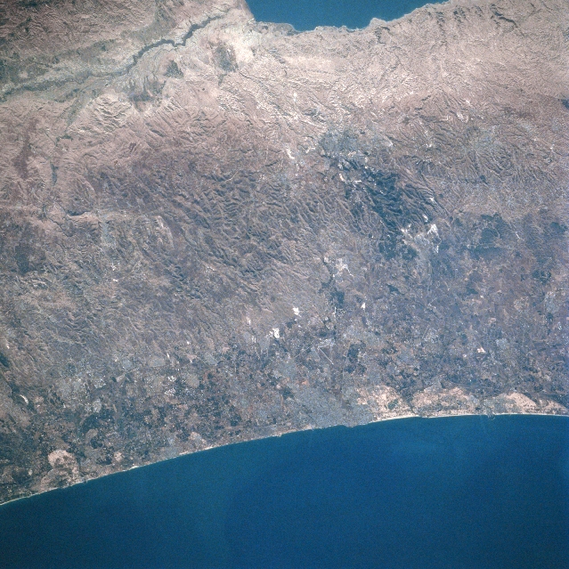 |
| STS079-810-048 Central Highland Region, Tel Aviv, Israel September 1996 Situated on the narrow, but fertile coastal plain, the largest city of Israel, Tel Aviv, is located midway between the center and bottom center of the image in this east-looking view. Tel Aviv is the major commercial, financial, communications, industrial, and cultural center in Israel. Construction, textiles, clothing, pharmaceuticals, electrical and electronic appliances, and printed materials are the main industries. The city is also a popular tourist resort with wide, attractive beaches. Just to the east of Tel Aviv are the Central Highlands, an area of hills and several small valleys. In the upper left and upper center of the image, a portion of the Jordan River Rift Valley and the Dead Sea are visible. |
| Images: | All Available Images Low-Resolution 396k |
|
| Mission: | STS079 |
|
| Roll - Frame: | 810 - 48 |
|
| Geographical Name: | ISRAEL |
|
| Features: | TEL AVIV, GAZA STRIP |
|
| Center Lat x Lon: | 31.5N x 35.0E |
|
| Film Exposure: | N | N=Normal exposure, U=Under exposed, O=Over exposed, F=out of Focus |
| Percentage of Cloud Cover-CLDP: | 0 |
|
| Camera:: | HB |
|
| Camera Tilt: | 38 | LO=Low Oblique, HO=High Oblique, NV=Near Vertical |
| Camera Focal Length: | 250 |
|
| Nadir to Photo Center Direction: | S | The direction from the nadir to the center point, N=North, S=South, E=East, W=West |
| Stereo?: | Y | Y=Yes there is an adjacent picture of the same area, N=No there isn't |
| Orbit Number: | 125 |
|
| Date: | 19960924 | YYYYMMDD |
| Time: | 062031 | GMT HHMMSS |
| Nadir Lat: | 34.0N |
Latitude of suborbital point of spacecraft |
| Nadir Lon: | 34.2E |
Longitude of suborbital point of spacecraft |
| Sun Azimuth: | 117 | Clockwise angle in degrees from north to the sun measured at the nadir point |
| Space Craft Altitude: | 201 | nautical miles |
| Sun Elevation: | 33 | Angle in degrees between the horizon and the sun, measured at the nadir point |
| Land Views: | UPLAND, COAST, RIFT |
|
| Water Views: | SEA, RIVER |
|
| Atmosphere Views: | |
|
| Man Made Views: | URBAN AREA |
|
| City Views: | |
|
Photo is not associated with any sequences | ||
| NASA Home Page |
JSC Home Page |
JSC Digital Image Collection |
Earth Science & Remote Sensing |
|
This service is provided by the International Space Station program and the JSC Earth Science & Remote Sensing Unit, ARES Division, Exploration Integration Science Directorate.

|