
Geographic Region: USA-ILLINOIS
Feature: DECATUR,LAKE SHELBYVILLE
|
Geographic Region: USA-ILLINOIS Feature: DECATUR,LAKE SHELBYVILLE |
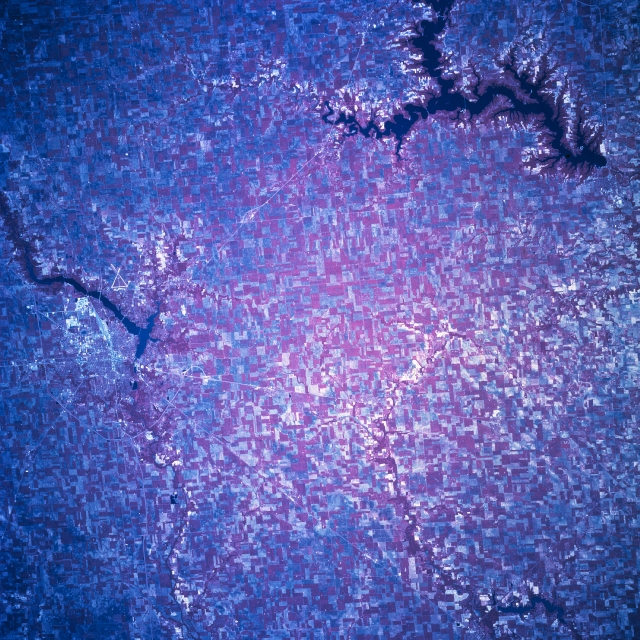 |
| STS078-758-096 Lake Shelbyville, Illinois, USA June 1996 The plains of central Illinois, which is part of the great Corn Belt, are covered by an abundance of cultivated fields (represented by different shades of reds, grays, and lighter colors in this color infrared image) covering the entire view. The large, dark serpentine-shaped feature along the southeast corner of the picture is Lake Shelbyville. Lake Decatur is another sizable, elongated (dark) feature along the northern edge of the image. The much smaller dark feature in the southwest corner of the scene is Lake Taylorville. The urban, built up area of Decatur is visible immediately west of Lake Decatur and the intersecting runways of Decatur Municipal Airport are located east of the lake. Most of Interstate Highway 72 (thin, light line) is visible as it skirts around the north and west side of Decatur. Several state and U. S. highways are also visible as they radiate outward from the southern limits of Decatur. |
| Images: | All Available Images Low-Resolution 428k |
|
| Mission: | STS078 |
|
| Roll - Frame: | 758 - 96 |
|
| Geographical Name: | USA-ILLINOIS |
|
| Features: | DECATUR,LAKE SHELBYVILLE |
|
| Center Lat x Lon: | 39.5N x 88W |
|
| Film Exposure: | N | N=Normal exposure, U=Under exposed, O=Over exposed, F=out of Focus |
| Percentage of Cloud Cover-CLDP: | 0 |
|
| Camera:: | HB |
|
| Camera Tilt: | 14 | LO=Low Oblique, HO=High Oblique, NV=Near Vertical |
| Camera Focal Length: | 250 |
|
| Nadir to Photo Center Direction: | NE | The direction from the nadir to the center point, N=North, S=South, E=East, W=West |
| Stereo?: | N | Y=Yes there is an adjacent picture of the same area, N=No there isn't |
| Orbit Number: | 129 |
|
| Date: | 19960628 | YYYYMMDD |
| Time: | 143711 | GMT HHMMSS |
| Nadir Lat: | 39.2N |
Latitude of suborbital point of spacecraft |
| Nadir Lon: | 88.5W |
Longitude of suborbital point of spacecraft |
| Sun Azimuth: | 95 | Clockwise angle in degrees from north to the sun measured at the nadir point |
| Space Craft Altitude: | 142 | nautical miles |
| Sun Elevation: | 45 | Angle in degrees between the horizon and the sun, measured at the nadir point |
| Land Views: | PLAIN, BASIN |
|
| Water Views: | LAKE, RIVER |
|
| Atmosphere Views: | |
|
| Man Made Views: | AGRICULTURE, HIGHWAY, AIRPORT |
|
| City Views: | |
|
Photo is not associated with any sequences | ||
| NASA Home Page |
JSC Home Page |
JSC Digital Image Collection |
Earth Science & Remote Sensing |
|
This service is provided by the International Space Station program and the JSC Earth Science & Remote Sensing Unit, ARES Division, Exploration Integration Science Directorate.

|