Geographic Region: INDONESIA-J
Feature: COAST,MANUK R.,SED,TANKS
|
Geographic Region: INDONESIA-J Feature: COAST,MANUK R.,SED,TANKS |
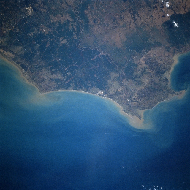 |
| STS078-750-013 Manuk River Mouth, Java, Indonesia July 1996 The Manuk River enters the view near the upper center of the image and flows generally northward across a gently rolling coastal plain emptying into the Java Sea at the right center of the image. The Manuk rises in the volcanic mountains of central Java and is 75 miles (121 km) long. Forest clearing along the coastal plain and in the mountain lowlands has increased erosion and the sediment flow into the Java Sea. Not only is increased sediment a problem, the increasing use of pesticides and fertilizers, has increased the destruction of coral reefs along Java's northern coast. Rice is the major crop grown along the coastal plain. |
| Images: | All Available Images Low-Resolution 320k |
|
| Mission: | STS078 |
|
| Roll - Frame: | 750 - 13 |
|
| Geographical Name: | INDONESIA-J |
|
| Features: | COAST,MANUK R.,SED,TANKS |
|
| Center Lat x Lon: | 6.5S x 108.5E |
|
| Film Exposure: | N | N=Normal exposure, U=Under exposed, O=Over exposed, F=out of Focus |
| Percentage of Cloud Cover-CLDP: | 0 |
|
| Camera:: | HB |
|
| Camera Tilt: | 21 | LO=Low Oblique, HO=High Oblique, NV=Near Vertical |
| Camera Focal Length: | 250 |
|
| Nadir to Photo Center Direction: | SW | The direction from the nadir to the center point, N=North, S=South, E=East, W=West |
| Stereo?: | Y | Y=Yes there is an adjacent picture of the same area, N=No there isn't |
| Orbit Number: | 140 |
|
| Date: | 19960629 | YYYYMMDD |
| Time: | 072843 | GMT HHMMSS |
| Nadir Lat: | 6S |
Latitude of suborbital point of spacecraft |
| Nadir Lon: | 109.3E |
Longitude of suborbital point of spacecraft |
| Sun Azimuth: | 308 | Clockwise angle in degrees from north to the sun measured at the nadir point |
| Space Craft Altitude: | 146 | nautical miles |
| Sun Elevation: | 41 | Angle in degrees between the horizon and the sun, measured at the nadir point |
| Land Views: | PLAIN, COAST, FOREST |
|
| Water Views: | RIVER, DELTA, SEDIMENT |
|
| Atmosphere Views: | |
|
| Man Made Views: | |
|
| City Views: | |
|
Photo is not associated with any sequences | ||
| NASA Home Page |
JSC Home Page |
JSC Digital Image Collection |
Earth Science & Remote Sensing |
|
This service is provided by the International Space Station program and the JSC Earth Science & Remote Sensing Unit, ARES Division, Exploration Integration Science Directorate.

|