Geographic Region: BAHRAIN
Feature: ISLAND,AL MANAMAH,SHOALS
|
Geographic Region: BAHRAIN Feature: ISLAND,AL MANAMAH,SHOALS |
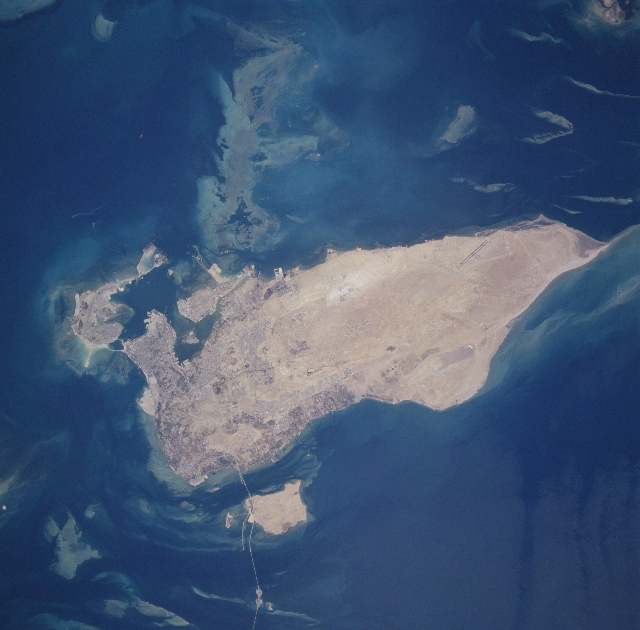 |
| STS078-748-012 Al Manamah, Bahrain June 1996 The capital city of Al Manamah, situated on the northeast tip of the island country of Bahrain, can be seen in this west-looking view. With a population of over 155000, Al Manamah is an international banking center with oil refineries, light industry, and is a duty free port. Tourism has also become a major industry. The main island of Bahrain is 30 miles (48 km) long north to south, and 10 miles (16 km) wide east to west. The island name comes from the Arabic word meaning "two seas". Bahrain is located 15 miles (24 km) off the eastern coast of Saudi Arabia in the Persian Gulf. The island is a low-lying barren desert with outcroppings of limestone that form low rolling hills, cliffs, and shallow ravines. The low rolling hills are called the Jabal Ad Dukhan (Mountains of Smoke) named for the mist that often wreathes the 543 foot-135 meters summit. Extending from the main island of Bahrain westward and exiting the view near the top center of the image is the causeway that connects Saudi Arabia to Bahrain. |
| Images: | All Available Images Low-Resolution 288k |
|
| Mission: | STS078 |
|
| Roll - Frame: | 748 - 12 |
|
| Geographical Name: | BAHRAIN |
|
| Features: | ISLAND,AL MANAMAH,SHOALS |
|
| Center Lat x Lon: | 26.0N x 50.5E |
|
| Film Exposure: | N | N=Normal exposure, U=Under exposed, O=Over exposed, F=out of Focus |
| Percentage of Cloud Cover-CLDP: | 0 |
|
| Camera:: | HB |
|
| Camera Tilt: | 14 | LO=Low Oblique, HO=High Oblique, NV=Near Vertical |
| Camera Focal Length: | 250 |
|
| Nadir to Photo Center Direction: | N | The direction from the nadir to the center point, N=North, S=South, E=East, W=West |
| Stereo?: | N | Y=Yes there is an adjacent picture of the same area, N=No there isn't |
| Orbit Number: | 78 |
|
| Date: | 19960625 | YYYYMMDD |
| Time: | 103109 | GMT HHMMSS |
| Nadir Lat: | 25.4N |
Latitude of suborbital point of spacecraft |
| Nadir Lon: | 50.5E |
Longitude of suborbital point of spacecraft |
| Sun Azimuth: | 272 | Clockwise angle in degrees from north to the sun measured at the nadir point |
| Space Craft Altitude: | 146 | nautical miles |
| Sun Elevation: | 65 | Angle in degrees between the horizon and the sun, measured at the nadir point |
| Land Views: | ISLAND, HILL, DESERT |
|
| Water Views: | GULF |
|
| Atmosphere Views: | |
|
| Man Made Views: | URBAN AREA, HIGHWAY |
|
| City Views: | AL MANAMAH |
|
Photo is not associated with any sequences | ||
| NASA Home Page |
JSC Home Page |
JSC Digital Image Collection |
Earth Science & Remote Sensing |
|
This service is provided by the International Space Station program and the JSC Earth Science & Remote Sensing Unit, ARES Division, Exploration Integration Science Directorate.

|