Geographic Region: TURKEY
Feature: ATATURK RES., SUNGLINT
|
Geographic Region: TURKEY Feature: ATATURK RES., SUNGLINT |
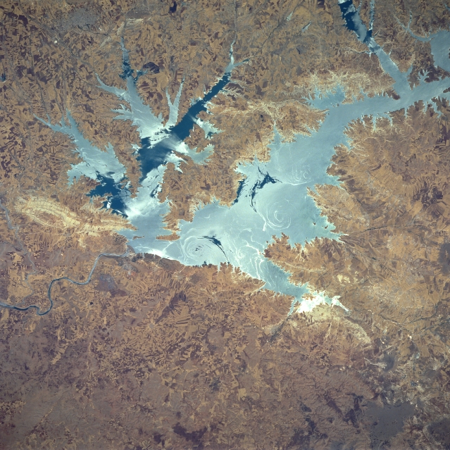 |
| STS078-747-080 Ataturk Reservoir, Turkey June 1996 Presently, the largest man-made lake in Turkey, the Ataturk Reservoir and Dam can be seen in this northeast-looking view. The reservoir, located in south central Turkey on the Euphrates River, was completed in the early 1990's. This dam and other dams further to the north in Turkey on the Euphrates River are causing political and water flow problems between Turkey and its neighbors to the south (Syria and Iraq). Discussions between the three countries to reach an agreeable solution to the problem are ongoing. This particular image was acquired with the waters of the reservoir in sun glint or sun glitter. The sun glint depicts the sun's reflection from the surface of the water. Slicks seen in the water reflect brightly and indicate a smooth water surface. Rough waters give off a diffuse, dull reflection (also reference STS078-747-081). Numerous angular field patterns are visible on the image surrounding the reservoir. The highly reflective surface area immediately to the west of the dam (left center of the image) appears to be an area where rock was extracted for the construction of the dam. |
| Images: | All Available Images Low-Resolution 392k |
|
| Mission: | STS078 |
|
| Roll - Frame: | 747 - 80 |
|
| Geographical Name: | TURKEY |
|
| Features: | ATATURK RES., SUNGLINT |
|
| Center Lat x Lon: | 37.5N x 38.5E |
|
| Film Exposure: | F | N=Normal exposure, U=Under exposed, O=Over exposed, F=out of Focus |
| Percentage of Cloud Cover-CLDP: | 0 |
|
| Camera:: | HB |
|
| Camera Tilt: | 10 | LO=Low Oblique, HO=High Oblique, NV=Near Vertical |
| Camera Focal Length: | 250 |
|
| Nadir to Photo Center Direction: | S | The direction from the nadir to the center point, N=North, S=South, E=East, W=West |
| Stereo?: | N | Y=Yes there is an adjacent picture of the same area, N=No there isn't |
| Orbit Number: | 77 |
|
| Date: | 19960625 | YYYYMMDD |
| Time: | 085255 | GMT HHMMSS |
| Nadir Lat: | 37.9N |
Latitude of suborbital point of spacecraft |
| Nadir Lon: | 38.3E |
Longitude of suborbital point of spacecraft |
| Sun Azimuth: | 149 | Clockwise angle in degrees from north to the sun measured at the nadir point |
| Space Craft Altitude: | 145 | nautical miles |
| Sun Elevation: | 74 | Angle in degrees between the horizon and the sun, measured at the nadir point |
| Land Views: | HILL |
|
| Water Views: | SUNGLINT, RESERVOIR, RIVER, EDDY |
|
| Atmosphere Views: | |
|
| Man Made Views: | DAM, AGRICULTURE |
|
| City Views: | |
|
Photo is not associated with any sequences | ||
| NASA Home Page |
JSC Home Page |
JSC Digital Image Collection |
Earth Science & Remote Sensing |
|
This service is provided by the International Space Station program and the JSC Earth Science & Remote Sensing Unit, ARES Division, Exploration Integration Science Directorate.

|