Geographic Region: TURKEY
Feature: ACI,BURDUR,& SALDA LAKES
|
Geographic Region: TURKEY Feature: ACI,BURDUR,& SALDA LAKES |
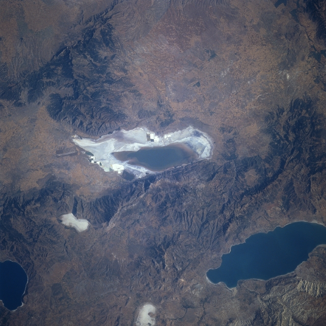 |
| STS078-740-072 Aci and Budur Lakes, Turkey June 1996 The rugged, semi-arid terrain of southwestern Turkey is visible in this northwest-looking view. Aci Lake's (center of the image) old shorelines are visible as the lake is in the process of evaporating. Lake Burdur is discernible toward the bottom right of the image. Near the bottom center of the image is the evaporated Yarash Lake. Salda Lake is visible near the bottom left of the image. Numerous faults traverse this area of Turkey, which makes this region prone to earthquakes. Wheat is grown in the valleys and plains of the region. |
| Images: | All Available Images Low-Resolution 336k |
|
| Mission: | STS078 |
|
| Roll - Frame: | 740 - 72 |
|
| Geographical Name: | TURKEY |
|
| Features: | ACI,BURDUR,& SALDA LAKES |
|
| Center Lat x Lon: | 38.0N x 30.0E |
|
| Film Exposure: | N | N=Normal exposure, U=Under exposed, O=Over exposed, F=out of Focus |
| Percentage of Cloud Cover-CLDP: | 0 |
|
| Camera:: | HB |
|
| Camera Tilt: | 22 | LO=Low Oblique, HO=High Oblique, NV=Near Vertical |
| Camera Focal Length: | 250 |
|
| Nadir to Photo Center Direction: | N | The direction from the nadir to the center point, N=North, S=South, E=East, W=West |
| Stereo?: | N | Y=Yes there is an adjacent picture of the same area, N=No there isn't |
| Orbit Number: | 219 |
|
| Date: | 19960704 | YYYYMMDD |
| Time: | 051141 | GMT HHMMSS |
| Nadir Lat: | 37.1N |
Latitude of suborbital point of spacecraft |
| Nadir Lon: | 30.2E |
Longitude of suborbital point of spacecraft |
| Sun Azimuth: | 80 | Clockwise angle in degrees from north to the sun measured at the nadir point |
| Space Craft Altitude: | 139 | nautical miles |
| Sun Elevation: | 27 | Angle in degrees between the horizon and the sun, measured at the nadir point |
| Land Views: | MOUNTAIN, PLAIN, ESCARPMENT |
|
| Water Views: | LAKE, PLAYA |
|
| Atmosphere Views: | |
|
| Man Made Views: | |
|
| City Views: | |
|
Photo is not associated with any sequences | ||
| NASA Home Page |
JSC Home Page |
JSC Digital Image Collection |
Earth Science & Remote Sensing |
|
This service is provided by the International Space Station program and the JSC Earth Science & Remote Sensing Unit, ARES Division, Exploration Integration Science Directorate.

|