
Geographic Region: USA-NORTH CAROLINA
Feature: PORTSMOUTH, DISMAL SWAMP
|
Geographic Region: USA-NORTH CAROLINA Feature: PORTSMOUTH, DISMAL SWAMP |
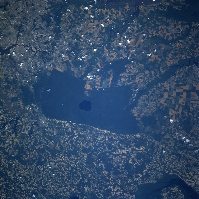 |
| STS078-736-042 Great Dismal Swamp, Virginia June 1996 The remains of the Great Dismal Swamp are visible at the center of the image in this west-southwest-looking view. Once covering an area of 2200 sq miles (5700 sq km) from the mouth of the James River southward to near Albemarle Sound, the Great Dismal Swamp has been reduced to an area of less than 600 sq miles (1554 sq km) or 30 miles (48 km) long and 10 miles (16 km) wide. Draining of the swamp began in 1763. Today, the swamp is a National Wildlife Refuge and with its dense forests and tangled undergrowth, is a favorite site for sportsmen and naturalists. Drummond Lake, 7 miles (11 km) long and 5 miles (8 km) wide, situated at near 20 feet (6 meters) above sea level, can be seen as a dark blue circular feature in the middle of the swamp. Portions of the city of Portsmouth, Virginia are discernible in the lower left portion of the image. A small portion of the Chawan River in North Carolina can be seen in the upper right portion of the image. |
| Images: | All Available Images Low-Resolution 373k |
|
| Mission: | STS078 |
|
| Roll - Frame: | 736 - 42 |
|
| Geographical Name: | USA-NORTH CAROLINA |
|
| Features: | PORTSMOUTH, DISMAL SWAMP |
|
| Center Lat x Lon: | 36.5N x 76.5W |
|
| Film Exposure: | N | N=Normal exposure, U=Under exposed, O=Over exposed, F=out of Focus |
| Percentage of Cloud Cover-CLDP: | 5 |
|
| Camera:: | HB |
|
| Camera Tilt: | 32 | LO=Low Oblique, HO=High Oblique, NV=Near Vertical |
| Camera Focal Length: | 250 |
|
| Nadir to Photo Center Direction: | W | The direction from the nadir to the center point, N=North, S=South, E=East, W=West |
| Stereo?: | N | Y=Yes there is an adjacent picture of the same area, N=No there isn't |
| Orbit Number: | 98 |
|
| Date: | 19960626 | YYYYMMDD |
| Time: | 161950 | GMT HHMMSS |
| Nadir Lat: | 36.3N |
Latitude of suborbital point of spacecraft |
| Nadir Lon: | 75W |
Longitude of suborbital point of spacecraft |
| Sun Azimuth: | 141 | Clockwise angle in degrees from north to the sun measured at the nadir point |
| Space Craft Altitude: | 144 | nautical miles |
| Sun Elevation: | 74 | Angle in degrees between the horizon and the sun, measured at the nadir point |
| Land Views: | FOREST, PLAIN |
|
| Water Views: | SWAMP, LAKE, RIVER |
|
| Atmosphere Views: | |
|
| Man Made Views: | AGRICULTURE, URBAN AREA |
|
| City Views: | |
|
Photo is not associated with any sequences | ||
| NASA Home Page |
JSC Home Page |
JSC Digital Image Collection |
Earth Science & Remote Sensing |
|
This service is provided by the International Space Station program and the JSC Earth Science & Remote Sensing Unit, ARES Division, Exploration Integration Science Directorate.

|