
Geographic Region: USA-OHIO
Feature: CINCINNATI, OHIO R.,AGR.
|
Geographic Region: USA-OHIO Feature: CINCINNATI, OHIO R.,AGR. |
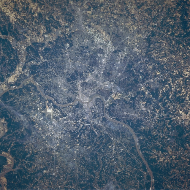 |
| STS078-736-030 Greater Cincinnati Area, Ohio, USA June 1996 The muddy Ohio River makes a northerly loop and flows between the larger city of Cincinnati (north bank of the river) and the smaller city of Covington, Kentucky (south bank) near the center of the picture. The Cincinnati-Northern Kentucky International Airport with its parallel runways and taxiways (highly reflective area) is west of Covington on the Kentucky side of the Ohio River. Sections of several Interstate Highways (thin, light lines) including Interstate Highways 71, 74, 75, and 275 (the beltway that encircles Cincinnati and Covington) and the bridges that cross the Ohio River are visible at various points throughout the image. Cultivated field patterns can be identified in the rural landscape and on some of the floodplains of the rivers that flow through this region. The darker terrain consists of undeveloped, usually hilly, forested land. |
| Images: | All Available Images Low-Resolution 403k |
|
| Mission: | STS078 |
|
| Roll - Frame: | 736 - 30 |
|
| Geographical Name: | USA-OHIO |
|
| Features: | CINCINNATI, OHIO R.,AGR. |
|
| Center Lat x Lon: | 39.0N x 84.5W |
|
| Film Exposure: | N | N=Normal exposure, U=Under exposed, O=Over exposed, F=out of Focus |
| Percentage of Cloud Cover-CLDP: | 5 |
|
| Camera:: | HB |
|
| Camera Tilt: | 25 | LO=Low Oblique, HO=High Oblique, NV=Near Vertical |
| Camera Focal Length: | 250 |
|
| Nadir to Photo Center Direction: | NE | The direction from the nadir to the center point, N=North, S=South, E=East, W=West |
| Stereo?: | N | Y=Yes there is an adjacent picture of the same area, N=No there isn't |
| Orbit Number: | 98 |
|
| Date: | 19960626 | YYYYMMDD |
| Time: | 161737 | GMT HHMMSS |
| Nadir Lat: | 38.2N |
Latitude of suborbital point of spacecraft |
| Nadir Lon: | 85.3W |
Longitude of suborbital point of spacecraft |
| Sun Azimuth: | 122 | Clockwise angle in degrees from north to the sun measured at the nadir point |
| Space Craft Altitude: | 144 | nautical miles |
| Sun Elevation: | 66 | Angle in degrees between the horizon and the sun, measured at the nadir point |
| Land Views: | FLOOD PLAIN, HILL |
|
| Water Views: | RIVER |
|
| Atmosphere Views: | |
|
| Man Made Views: | AIRPORT, HIGHWAY |
|
| City Views: | |
|
Photo is not associated with any sequences | ||
| NASA Home Page |
JSC Home Page |
JSC Digital Image Collection |
Earth Science & Remote Sensing |
|
This service is provided by the International Space Station program and the JSC Earth Science & Remote Sensing Unit, ARES Division, Exploration Integration Science Directorate.

|