
Geographic Region: USA-MISSOURI
Feature: ST. JOSEPH, MISSOURI R.
|
Geographic Region: USA-MISSOURI Feature: ST. JOSEPH, MISSOURI R. |
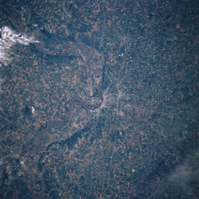 |
| STS078-734-54 St. Joseph, Missouri, USA June 1996 Although this image shows a landscape that is intensively cultivated, the wooded escarpment (darker fringe of land along both sides of the floodplain) helps to frame the boundary of the floodplain of the Missouri River. Some of the gridded street pattern of St. Joseph is visible along the east bank of the Missouri River. The major highways in the St. Joseph area can be traced across the cultivated plain, especially Interstate Highways 29 and 229 and U. S. Highway 36. It is interesting to note that Rosecrans Memorial Airport, located due west of St. Joseph and west of the main channel of the Missouri River, is located in the state of Missouri. The small city of Atchison, Kansas is barely visible near the southwest edge of the picture along the west bank of the Missouri River. |
| Images: | All Available Images Low-Resolution 392k |
|
| Mission: | STS078 |
|
| Roll - Frame: | 734 - 54 |
|
| Geographical Name: | USA-MISSOURI |
|
| Features: | ST. JOSEPH, MISSOURI R. |
|
| Center Lat x Lon: | 40.0N x 95W |
|
| Film Exposure: | N | N=Normal exposure, U=Under exposed, O=Over exposed, F=out of Focus |
| Percentage of Cloud Cover-CLDP: | 5 |
|
| Camera:: | HB |
|
| Camera Tilt: | 21 | LO=Low Oblique, HO=High Oblique, NV=Near Vertical |
| Camera Focal Length: | 250 |
|
| Nadir to Photo Center Direction: | NW | The direction from the nadir to the center point, N=North, S=South, E=East, W=West |
| Stereo?: | N | Y=Yes there is an adjacent picture of the same area, N=No there isn't |
| Orbit Number: | 82 |
|
| Date: | 19960625 | YYYYMMDD |
| Time: | 161801 | GMT HHMMSS |
| Nadir Lat: | 39.2N |
Latitude of suborbital point of spacecraft |
| Nadir Lon: | 94.5W |
Longitude of suborbital point of spacecraft |
| Sun Azimuth: | 112 | Clockwise angle in degrees from north to the sun measured at the nadir point |
| Space Craft Altitude: | 144 | nautical miles |
| Sun Elevation: | 60 | Angle in degrees between the horizon and the sun, measured at the nadir point |
| Land Views: | FLOOD PLAIN |
|
| Water Views: | RIVER |
|
| Atmosphere Views: | |
|
| Man Made Views: | URBAN AREA, AIRPORT, HIGHWAY |
|
| City Views: | |
|
Photo is not associated with any sequences | ||
| NASA Home Page |
JSC Home Page |
JSC Digital Image Collection |
Earth Science & Remote Sensing |
|
This service is provided by the International Space Station program and the JSC Earth Science & Remote Sensing Unit, ARES Division, Exploration Integration Science Directorate.

|