Geographic Region: INDONESIA-B
Feature: CAPE SELATAN, SED. PLUME
|
Geographic Region: INDONESIA-B Feature: CAPE SELATAN, SED. PLUME |
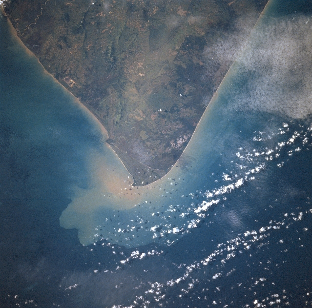 |
| STS078-727-022 Cape Selatan, Borneo (Kalimantan) June 1996 The southern most point on the island of Borneo (Kalimantan), Cape Selatan, is visible in this near-nadir view. Once this whole region was a swamp, but the land area north of the cape is being cleared for rubber plantations and grazing for cattle. The sediment along the coast is from the Barito River to the north (not on image) and from small streams near the tip of the cape where land has been cleared. The forested hills of the southern Besar Range are visible along the southeastern coast midway between the upper center and upper right of the image. |
| Images: | All Available Images Low-Resolution 352k |
|
| Mission: | STS078 |
|
| Roll - Frame: | 727 - 22 |
|
| Geographical Name: | INDONESIA-B |
|
| Features: | CAPE SELATAN, SED. PLUME |
|
| Center Lat x Lon: | 4S x 114.5E |
|
| Film Exposure: | N | N=Normal exposure, U=Under exposed, O=Over exposed, F=out of Focus |
| Percentage of Cloud Cover-CLDP: | 15 |
|
| Camera:: | HB |
|
| Camera Tilt: | LO | LO=Low Oblique, HO=High Oblique, NV=Near Vertical |
| Camera Focal Length: | 100 |
|
| Nadir to Photo Center Direction: | The direction from the nadir to the center point, N=North, S=South, E=East, W=West |
|
| Stereo?: | N | Y=Yes there is an adjacent picture of the same area, N=No there isn't |
| Orbit Number: | |
|
| Date: | 1996____ | YYYYMMDD |
| Time: | GMT HHMMSS |
|
| Nadir Lat: | N |
Latitude of suborbital point of spacecraft |
| Nadir Lon: | E |
Longitude of suborbital point of spacecraft |
| Sun Azimuth: | Clockwise angle in degrees from north to the sun measured at the nadir point |
|
| Space Craft Altitude: | nautical miles |
|
| Sun Elevation: | Angle in degrees between the horizon and the sun, measured at the nadir point |
|
| Land Views: | CAPE, COAST, HILL, FOREST |
|
| Water Views: | SEDIMENT |
|
| Atmosphere Views: | |
|
| Man Made Views: | |
|
| City Views: | |
|
Photo is not associated with any sequences | ||
| NASA Home Page |
JSC Home Page |
JSC Digital Image Collection |
Earth Science & Remote Sensing |
|
This service is provided by the International Space Station program and the JSC Earth Science & Remote Sensing Unit, ARES Division, Exploration Integration Science Directorate.

|