Geographic Region: GALAPAGOS ISLANDS
Feature: ISABELA,SAN SALVADOR,VOL
|
Geographic Region: GALAPAGOS ISLANDS Feature: ISABELA,SAN SALVADOR,VOL |
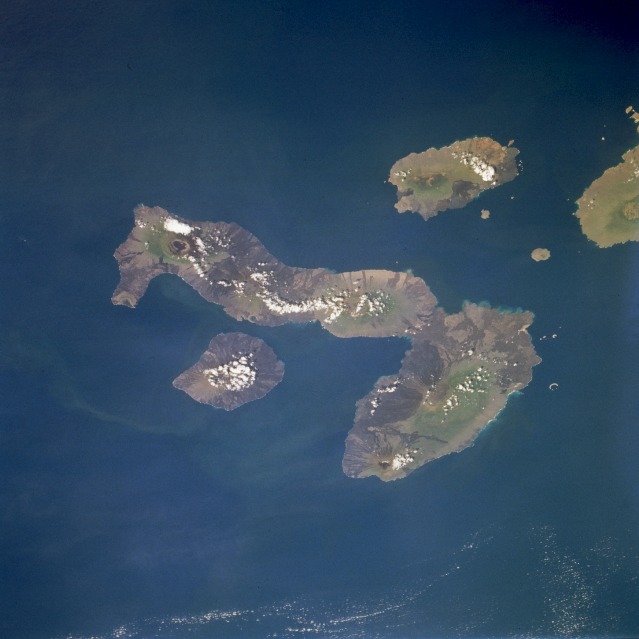 |
| STS077-711-011 Galápagos Islands, Ecuador May 1996 Isabela, the largest of the Galápagos Islands; Fernandina; San Salvador; and a partial view of Santa Cruz, are apparent in this southwest-looking, low-oblique photograph. Located on the equator 600 miles (1000 kilometers) west of Ecuador, the rugged volcanic islands began forming 4 to 5 million years ago. Sea-horse-shaped Isabela Island covers 1771 square miles (4588 square kilometers) and has five active volcanoes. Fernandina Island, west-southwest of Isabela, covers 248 square miles (642 square kilometers) and has a single large active volcano with a very distinct caldera that is sometimes filled with water. East-northeast of Isabella lies San Salvador that covers 226 square miles (585 square kilometers). The islands, famous for their diversity of unique wildlife, were visited in 1835 by Charles Darwin, who gathered data that was later used in support of the theory of natural selection. |
| Images: | All Available Images Low-Resolution 72k |
|
| Mission: | STS077 |
|
| Roll - Frame: | 711 - 11 |
|
| Geographical Name: | GALAPAGOS ISLANDS |
|
| Features: | ISABELA,SAN SALVADOR,VOL |
|
| Center Lat x Lon: | 0.5S x 91W |
|
| Film Exposure: | N | N=Normal exposure, U=Under exposed, O=Over exposed, F=out of Focus |
| Percentage of Cloud Cover-CLDP: | 5 |
|
| Camera:: | HB |
|
| Camera Tilt: | 35 | LO=Low Oblique, HO=High Oblique, NV=Near Vertical |
| Camera Focal Length: | 100 |
|
| Nadir to Photo Center Direction: | SW | The direction from the nadir to the center point, N=North, S=South, E=East, W=West |
| Stereo?: | Y | Y=Yes there is an adjacent picture of the same area, N=No there isn't |
| Orbit Number: | 7 |
|
| Date: | 19960519 | YYYYMMDD |
| Time: | 200735 | GMT HHMMSS |
| Nadir Lat: | .9N |
Latitude of suborbital point of spacecraft |
| Nadir Lon: | 89.9W |
Longitude of suborbital point of spacecraft |
| Sun Azimuth: | 303 | Clockwise angle in degrees from north to the sun measured at the nadir point |
| Space Craft Altitude: | 153 | nautical miles |
| Sun Elevation: | 53 | Angle in degrees between the horizon and the sun, measured at the nadir point |
| Land Views: | ISLAND, VOLCANO, CRATER |
|
| Water Views: | OCEAN |
|
| Atmosphere Views: | |
|
| Man Made Views: | |
|
| City Views: | |
|
Photo is not associated with any sequences | ||
| NASA Home Page |
JSC Home Page |
JSC Digital Image Collection |
Earth Science & Remote Sensing |
|
This service is provided by the International Space Station program and the JSC Earth Science & Remote Sensing Unit, ARES Division, Exploration Integration Science Directorate.

|