Geographic Region: MALAYSIA
Feature: KELANTAN R., COAST, TAIL
|
Geographic Region: MALAYSIA Feature: KELANTAN R., COAST, TAIL |
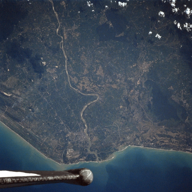 |
| STS075-733-095 Kelantan River, Malaysia March 1996 Located near the border of Thailand (extreme right), the Kelantan River and its delta are visible in this southwest-looking view. Over 150 miles (242 km) long, the Kelantan rises in the interior mountains of the Malaysian Peninisula and flows generally north-northeast before emptying into the South China Sea (bottom of the image). The river has numerous tributaries and is navigable for much of its course. Much clearing (center of the image) of the fertile coastal plain is underway, with rice fields and rubber and coconut plantations taking over. Barely discernible on the east (left) bank of the Kelantan River (midway between the bottom center and center of the image) is the modern commercial city of Kota Baharu. |
| Images: | All Available Images Low-Resolution 354k |
|
| Mission: | STS075 |
|
| Roll - Frame: | 733 - 95 |
|
| Geographical Name: | MALAYSIA |
|
| Features: | KELANTAN R., COAST, TAIL |
|
| Center Lat x Lon: | 6.0N x 102.0E |
|
| Film Exposure: | N | N=Normal exposure, U=Under exposed, O=Over exposed, F=out of Focus |
| Percentage of Cloud Cover-CLDP: | 5 |
|
| Camera:: | HB |
|
| Camera Tilt: | 16 | LO=Low Oblique, HO=High Oblique, NV=Near Vertical |
| Camera Focal Length: | 250 |
|
| Nadir to Photo Center Direction: | W | The direction from the nadir to the center point, N=North, S=South, E=East, W=West |
| Stereo?: | Y | Y=Yes there is an adjacent picture of the same area, N=No there isn't |
| Orbit Number: | 121 |
|
| Date: | 19960301 | YYYYMMDD |
| Time: | 091122 | GMT HHMMSS |
| Nadir Lat: | 5.7N |
Latitude of suborbital point of spacecraft |
| Nadir Lon: | 102.7E |
Longitude of suborbital point of spacecraft |
| Sun Azimuth: | 258 | Clockwise angle in degrees from north to the sun measured at the nadir point |
| Space Craft Altitude: | 158 | nautical miles |
| Sun Elevation: | 31 | Angle in degrees between the horizon and the sun, measured at the nadir point |
| Land Views: | PLAIN, FOREST |
|
| Water Views: | RIVER, SEDIMENT |
|
| Atmosphere Views: | |
|
| Man Made Views: | AGRICULTURE |
|
| City Views: | |
|
Photo is not associated with any sequences | ||
| NASA Home Page |
JSC Home Page |
JSC Digital Image Collection |
Earth Science & Remote Sensing |
|
This service is provided by the International Space Station program and the JSC Earth Science & Remote Sensing Unit, ARES Division, Exploration Integration Science Directorate.

|