Geographic Region: USA-FLORIDA
Feature: FLORIDA KEYS,REEFS,MIAMI
|
Geographic Region: USA-FLORIDA Feature: FLORIDA KEYS,REEFS,MIAMI |
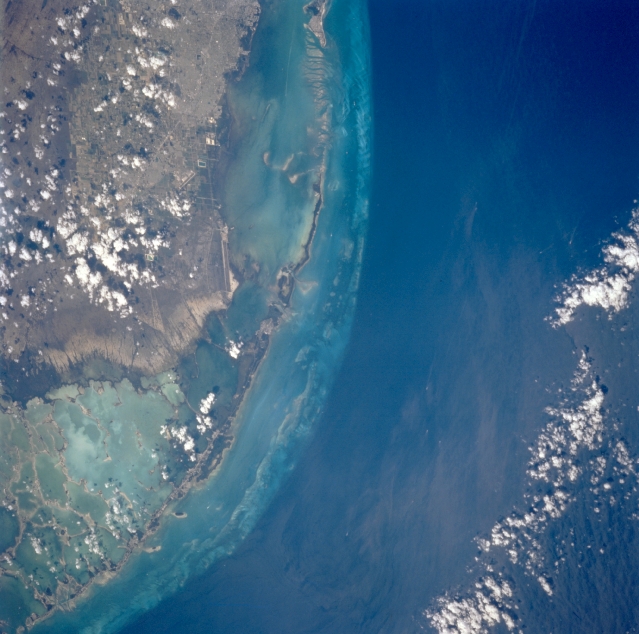 |
| STS075-728-095 Northern Florida Keys, U.S.A. March 1996 The different shades of color represent different depths of water--the dark blues show the deeper water of the north-flowing Gulf Stream in the Straits of Florida, approximately 900 feet (275 meters) deep; the lighter waters adjacent to the Florida Keys average 10 feet (3 meters) in depth; and the highly reflective aquas denote very shallow [3 feet (1 meter)] Florida Bay with a multitude of vegetated islands (lower left). Visible are a small section of the southeastern portion of The Everglades and the mangrove swamp north of Florida Bay; the coral reefs and limestone islands that make up the southwest-arcing Florida Keys; most of shallow Biscayne Bay (upper center); and the vague outline of the southern extent of greater Miami (upper left). |
| Images: | All Available Images Low-Resolution 306k |
|
| Mission: | STS075 |
|
| Roll - Frame: | 728 - 95 |
|
| Geographical Name: | USA-FLORIDA |
|
| Features: | FLORIDA KEYS,REEFS,MIAMI |
|
| Center Lat x Lon: | 25.5N x 80W |
|
| Film Exposure: | N | N=Normal exposure, U=Under exposed, O=Over exposed, F=out of Focus |
| Percentage of Cloud Cover-CLDP: | 15 |
|
| Camera:: | HB |
|
| Camera Tilt: | 36 | LO=Low Oblique, HO=High Oblique, NV=Near Vertical |
| Camera Focal Length: | 250 |
|
| Nadir to Photo Center Direction: | SW | The direction from the nadir to the center point, N=North, S=South, E=East, W=West |
| Stereo?: | Y | Y=Yes there is an adjacent picture of the same area, N=No there isn't |
| Orbit Number: | 111 |
|
| Date: | 19960229 | YYYYMMDD |
| Time: | 175536 | GMT HHMMSS |
| Nadir Lat: | 26.5N |
Latitude of suborbital point of spacecraft |
| Nadir Lon: | 78.4W |
Longitude of suborbital point of spacecraft |
| Sun Azimuth: | 193 | Clockwise angle in degrees from north to the sun measured at the nadir point |
| Space Craft Altitude: | 155 | nautical miles |
| Sun Elevation: | 55 | Angle in degrees between the horizon and the sun, measured at the nadir point |
| Land Views: | COAST, ISLAND |
|
| Water Views: | OCEAN, BAY |
|
| Atmosphere Views: | |
|
| Man Made Views: | |
|
| City Views: | |
|
Photo is not associated with any sequences | ||
| NASA Home Page |
JSC Home Page |
JSC Digital Image Collection |
Earth Science & Remote Sensing |
|
This service is provided by the International Space Station program and the JSC Earth Science & Remote Sensing Unit, ARES Division, Exploration Integration Science Directorate.

|