Geographic Region: LESSER ANTILLES
Feature: BONAIRE ISLAND
|
Geographic Region: LESSER ANTILLES Feature: BONAIRE ISLAND |
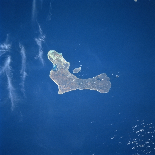 |
| STS075-706-41 Bonaire Island, Netherland Antilles March 1996 Located 50 miles (80 km) north of Venezuela, the semi-desert landscape of Bonaire Island can be seen in this south-looking view. The island of Bonaire lies on top of a volcanic ridge off the coast of South America. The island is 24 miles (39 km) long and is 3-7 miles (5 to 11 km) wide, and covers an area of 112 sq. miles (290 sq. km). The highest elevation of the island is Brandaris Hill at 784 feet (240 meters). The island is fringed with coral reefs. Tourism is one of the most important industries of the island along with the production of sisal and salt. Goats and sheep are also raised. Over 190 species of birds, including roseate flamingos, call Bonaire their home. Diving and snorkeling are two of the most popular recreational sport activities. |
| Images: | All Available Images Low-Resolution 244k |
|
| Mission: | STS075 |
|
| Roll - Frame: | 706 - 41 |
|
| Geographical Name: | LESSER ANTILLES |
|
| Features: | BONAIRE ISLAND |
|
| Center Lat x Lon: | 12.0N x 68.5W |
|
| Film Exposure: | N | N=Normal exposure, U=Under exposed, O=Over exposed, F=out of Focus |
| Percentage of Cloud Cover-CLDP: | 10 |
|
| Camera:: | HB |
|
| Camera Tilt: | 21 | LO=Low Oblique, HO=High Oblique, NV=Near Vertical |
| Camera Focal Length: | 250 |
|
| Nadir to Photo Center Direction: | N | The direction from the nadir to the center point, N=North, S=South, E=East, W=West |
| Stereo?: | N | Y=Yes there is an adjacent picture of the same area, N=No there isn't |
| Orbit Number: | 128 |
|
| Date: | 19960301 | YYYYMMDD |
| Time: | 193935 | GMT HHMMSS |
| Nadir Lat: | 11.0N |
Latitude of suborbital point of spacecraft |
| Nadir Lon: | 68.3W |
Longitude of suborbital point of spacecraft |
| Sun Azimuth: | 249 | Clockwise angle in degrees from north to the sun measured at the nadir point |
| Space Craft Altitude: | 157 | nautical miles |
| Sun Elevation: | 43 | Angle in degrees between the horizon and the sun, measured at the nadir point |
| Land Views: | ISLAND, HILL |
|
| Water Views: | SEA |
|
| Atmosphere Views: | |
|
| Man Made Views: | |
|
| City Views: | |
|
Photo is not associated with any sequences | ||
| NASA Home Page |
JSC Home Page |
JSC Digital Image Collection |
Earth Science & Remote Sensing |
|
This service is provided by the International Space Station program and the JSC Earth Science & Remote Sensing Unit, ARES Division, Exploration Integration Science Directorate.

|