
Geographic Region: USA-UTAH
Feature: DESERT, GREAT SALT LAKE
|
Geographic Region: USA-UTAH Feature: DESERT, GREAT SALT LAKE |
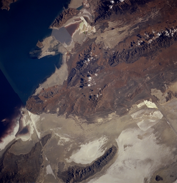 |
| STS074-711-015 Great Salt Lake Desert and Cedar Mountains, Utah, U.S.A. November 1995 The western portion of the Great Salt Lake appears in this east-southeast-looking, low-oblique photograph. The bridge and tracks of the Union Pacific Railroad appear as a straight line (left bottom of photograph). To the south, Interstate Highway 80 bisects the Great Salt Lake Desert, once the floor of prehistoric Lake Bonneville. South of the elongated Newfoundland Mountains (bottom center) appear the Cedar Mountains. Skull Valley Indian Reservation lies in the flat, desert-like area between the Cedar Mountains and the Newfoundland Mountains. Commercial extracting industrial patterns are discernible near the top center of the photograph. |
| Images: | All Available Images Low-Resolution 300k |
|
| Mission: | STS074 |
|
| Roll - Frame: | 711 - 15 |
|
| Geographical Name: | USA-UTAH |
|
| Features: | DESERT, GREAT SALT LAKE |
|
| Center Lat x Lon: | 41.0N x 113W |
|
| Film Exposure: | N | N=Normal exposure, U=Under exposed, O=Over exposed, F=out of Focus |
| Percentage of Cloud Cover-CLDP: | 0 |
|
| Camera:: | HB |
|
| Camera Tilt: | 22 | LO=Low Oblique, HO=High Oblique, NV=Near Vertical |
| Camera Focal Length: | 250 |
|
| Nadir to Photo Center Direction: | E | The direction from the nadir to the center point, N=North, S=South, E=East, W=West |
| Stereo?: | Y | Y=Yes there is an adjacent picture of the same area, N=No there isn't |
| Orbit Number: | 38 |
|
| Date: | 19951114 | YYYYMMDD |
| Time: | 211758 | GMT HHMMSS |
| Nadir Lat: | 41.5N |
Latitude of suborbital point of spacecraft |
| Nadir Lon: | 114.3W |
Longitude of suborbital point of spacecraft |
| Sun Azimuth: | 211 | Clockwise angle in degrees from north to the sun measured at the nadir point |
| Space Craft Altitude: | 210 | nautical miles |
| Sun Elevation: | 25 | Angle in degrees between the horizon and the sun, measured at the nadir point |
| Land Views: | DESERT, MOUNTAIN |
|
| Water Views: | PLAYA |
|
| Atmosphere Views: | |
|
| Man Made Views: | |
|
| City Views: | |
|
Photo is not associated with any sequences | ||
| NASA Home Page |
JSC Home Page |
JSC Digital Image Collection |
Earth Science & Remote Sensing |
|
This service is provided by the International Space Station program and the JSC Earth Science & Remote Sensing Unit, ARES Division, Exploration Integration Science Directorate.

|