
Geographic Region: USA-SOUTH CAROLINA
Feature: CHARLESTON, RIVERS,MARSH
|
Geographic Region: USA-SOUTH CAROLINA Feature: CHARLESTON, RIVERS,MARSH |
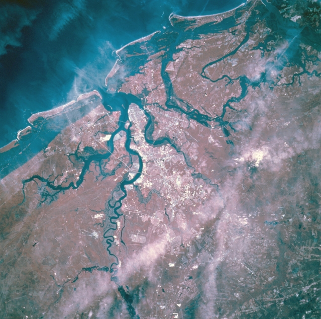 |
| STS073-750-032 Charleston, South Carolina, U.S.A. October 1995 Easy differentiation between land and water forms surrounding Charleston is provided by color infrared film. Some cloud formations obscure the landscapes and waterscapes; however, the darker rivers, bays, estuaries, and Atlantic Ocean stand out in contrast to both vegetated and nonvegetated land areas. The red hues depict gradations of green vegetation, and the whitish surfaces are highways, bridges, rooftops, and commercial areas. Only two rivers are apparent--the Ashley River that forms the northwest side of the peninsula that makes up downtown Charleston and the Cooper River that creates the eastern boundary of the same peninsula that protrudes southeast into Charleston Harbor--the other waterways are part of the interconnected and complex coastal wetlands. The dense vegetation east of Cooper River is Francis Marion National Forest. |
| Images: | All Available Images Low-Resolution 353k |
|
| Mission: | STS073 |
|
| Roll - Frame: | 750 - 32 |
|
| Geographical Name: | USA-SOUTH CAROLINA |
|
| Features: | CHARLESTON, RIVERS,MARSH |
|
| Center Lat x Lon: | 33.0N x 80W |
|
| Film Exposure: | N | N=Normal exposure, U=Under exposed, O=Over exposed, F=out of Focus |
| Percentage of Cloud Cover-CLDP: | 20 |
|
| Camera:: | HB |
|
| Camera Tilt: | 28 | LO=Low Oblique, HO=High Oblique, NV=Near Vertical |
| Camera Focal Length: | 250 |
|
| Nadir to Photo Center Direction: | W | The direction from the nadir to the center point, N=North, S=South, E=East, W=West |
| Stereo?: | Y | Y=Yes there is an adjacent picture of the same area, N=No there isn't |
| Orbit Number: | 84 |
|
| Date: | 19951025 | YYYYMMDD |
| Time: | 165913 | GMT HHMMSS |
| Nadir Lat: | 32.5N |
Latitude of suborbital point of spacecraft |
| Nadir Lon: | 78.8W |
Longitude of suborbital point of spacecraft |
| Sun Azimuth: | 180 | Clockwise angle in degrees from north to the sun measured at the nadir point |
| Space Craft Altitude: | 145 | nautical miles |
| Sun Elevation: | 46 | Angle in degrees between the horizon and the sun, measured at the nadir point |
| Land Views: | COAST, PLAIN, ISLAND, PENINSULA |
|
| Water Views: | RIVER, ESTUARY |
|
| Atmosphere Views: | |
|
| Man Made Views: | URBAN AREA, HIGHWAY |
|
| City Views: | |
|
Photo is not associated with any sequences | ||
| NASA Home Page |
JSC Home Page |
JSC Digital Image Collection |
Earth Science & Remote Sensing |
|
This service is provided by the International Space Station program and the JSC Earth Science & Remote Sensing Unit, ARES Division, Exploration Integration Science Directorate.

|