
Geographic Region: USA-CALIFORNIA
Feature: POINT REYES,COAST RANGES
|
Geographic Region: USA-CALIFORNIA Feature: POINT REYES,COAST RANGES |
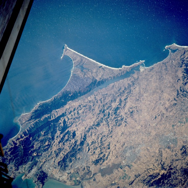 |
| STS073-726-004 Point Reyes National Seashore, California, U.S.A. October 1995 This spectacular, west-looking, low-oblique photograph highlights the Point Reyes National Seashore located approximately 35 miles (56 kilometers) northwest of San Francisco. The U.S. Congress created a national preserve in 1962 to include Point Reyes, a triangular peninsula. It is an area of exceptional beauty, with blunt headlands jutting into the sea and grass-tufted dunes lying along sheltered beaches. Within the preserve is the high, forested Inverness Ridge, which has a small grove of coast redwoods. Offshore rocks house many bird rookeries and sea lion herds. The famous San Andreas Fault (partially filled with water) can be seen passing northwest-southeast along the east side of the park. During the 1906 earthquake that destroyed most of the city of San Francisco, Point Reyes suffered a 15- to 20-foot (5- to 7-meter) horizontal displacement of rock along the fault scarp. Formed by the San Andreas Fault, Drakes Bay, an inlet of the Pacific Ocean southeast of Point Reyes, was visited by Sir Francis Drake in 1579. Discernible near the northeast edge of the photograph is the small city of Petaluma, a large poultry and dairy center that manufactures cheese, twine, fishing lines, canvas goods, and fabricated metal. |
| Images: | All Available Images Low-Resolution 160k |
|
| Mission: | STS073 |
|
| Roll - Frame: | 726 - 4 |
|
| Geographical Name: | USA-CALIFORNIA |
|
| Features: | POINT REYES,COAST RANGES |
|
| Center Lat x Lon: | 38.0N x 123W |
|
| Film Exposure: | N | N=Normal exposure, U=Under exposed, O=Over exposed, F=out of Focus |
| Percentage of Cloud Cover-CLDP: | 0 |
|
| Camera:: | HB |
|
| Camera Tilt: | LO | LO=Low Oblique, HO=High Oblique, NV=Near Vertical |
| Camera Focal Length: | 250 |
|
| Nadir to Photo Center Direction: | The direction from the nadir to the center point, N=North, S=South, E=East, W=West |
|
| Stereo?: | Y | Y=Yes there is an adjacent picture of the same area, N=No there isn't |
| Orbit Number: | |
|
| Date: | 1995____ | YYYYMMDD |
| Time: | GMT HHMMSS |
|
| Nadir Lat: | N |
Latitude of suborbital point of spacecraft |
| Nadir Lon: | E |
Longitude of suborbital point of spacecraft |
| Sun Azimuth: | Clockwise angle in degrees from north to the sun measured at the nadir point |
|
| Space Craft Altitude: | nautical miles |
|
| Sun Elevation: | Angle in degrees between the horizon and the sun, measured at the nadir point |
|
| Land Views: | COAST, FAULT, MOUNTAIN, VALLEY, PENINSULA |
|
| Water Views: | OCEAN, RIVER, BAY, ESTUARY |
|
| Atmosphere Views: | |
|
| Man Made Views: | AGRICULTURE |
|
| City Views: | |
|
Photo is not associated with any sequences | ||
| NASA Home Page |
JSC Home Page |
JSC Digital Image Collection |
Earth Science & Remote Sensing |
|
This service is provided by the International Space Station program and the JSC Earth Science & Remote Sensing Unit, ARES Division, Exploration Integration Science Directorate.

|