
Geographic Region: USA-UTAH
Feature: LAKE POWELL
|
Geographic Region: USA-UTAH Feature: LAKE POWELL |
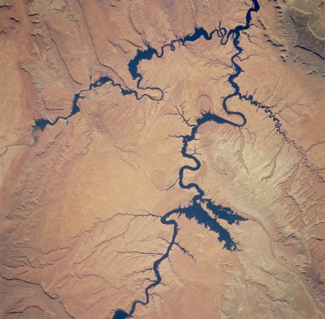 |
| STS073-726-017 Colorado, San Juan, and Escalante Rivers, Utah, U.S.A. September 1995 Glen Canyon National Recreation Area and Lake Powell are apparent in this south-southwest-looking, low-oblique photograph. The southwestern edge of the Kaiparowits Plateau is discernible in the upper right portion of the photograph. The Escalante, San Juan, and Colorado Rivers can be seen joining Lake Powell. The light greenish-red rocks of the Waterpocket Fold are visible northeast of the Escalante River. |
| Images: | All Available Images Low-Resolution 340k |
|
| Mission: | STS073 |
|
| Roll - Frame: | 726 - 17 |
|
| Geographical Name: | USA-UTAH |
|
| Features: | LAKE POWELL |
|
| Center Lat x Lon: | 37.5N x 110.5W |
|
| Film Exposure: | N | N=Normal exposure, U=Under exposed, O=Over exposed, F=out of Focus |
| Percentage of Cloud Cover-CLDP: | 0 |
|
| Camera:: | HB |
|
| Camera Tilt: | LO=Low Oblique, HO=High Oblique, NV=Near Vertical |
|
| Camera Focal Length: | 250 |
|
| Nadir to Photo Center Direction: | The direction from the nadir to the center point, N=North, S=South, E=East, W=West |
|
| Stereo?: | Y | Y=Yes there is an adjacent picture of the same area, N=No there isn't |
| Orbit Number: | |
|
| Date: | 1995____ | YYYYMMDD |
| Time: | GMT HHMMSS |
|
| Nadir Lat: | N |
Latitude of suborbital point of spacecraft |
| Nadir Lon: | E |
Longitude of suborbital point of spacecraft |
| Sun Azimuth: | Clockwise angle in degrees from north to the sun measured at the nadir point |
|
| Space Craft Altitude: | nautical miles |
|
| Sun Elevation: | Angle in degrees between the horizon and the sun, measured at the nadir point |
|
| Land Views: | PLATEAU |
|
| Water Views: | RIVER |
|
| Atmosphere Views: | |
|
| Man Made Views: | |
|
| City Views: | |
|
Photo is not associated with any sequences | ||
| NASA Home Page |
JSC Home Page |
JSC Digital Image Collection |
Earth Science & Remote Sensing |
|
This service is provided by the International Space Station program and the JSC Earth Science & Remote Sensing Unit, ARES Division, Exploration Integration Science Directorate.

|