
Geographic Region: USA-MISSOURI
Feature: MO RIVER, AGRICULTURE, RIVERS
|
Geographic Region: USA-MISSOURI Feature: MO RIVER, AGRICULTURE, RIVERS |
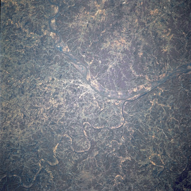 |
| STS073-716-086 Missouri River and Jefferson City, Missouri, U.S.A. October 1995 Jefferson City, the capital of Missouri, and the Missouri River floodplain that still shows the scars from the floods of the spring and early summer of 1993 are visible in this near-vertical photograph. Apparent are the Osage River as it winds its way northeastward and enters the Missouri River east of Jefferson City and the eroded upland of the Ozark Plateau. |
| Images: | All Available Images Low-Resolution 174k |
|
| Mission: | STS073 |
|
| Roll - Frame: | 716 - 86 |
|
| Geographical Name: | USA-MISSOURI |
|
| Features: | MO RIVER, AGRICULTURE, RIVERS |
|
| Center Lat x Lon: | 38.5N x 92W |
|
| Film Exposure: | N | N=Normal exposure, U=Under exposed, O=Over exposed, F=out of Focus |
| Percentage of Cloud Cover-CLDP: | 0 |
|
| Camera:: | HB |
|
| Camera Tilt: | 18 | LO=Low Oblique, HO=High Oblique, NV=Near Vertical |
| Camera Focal Length: | 250 |
|
| Nadir to Photo Center Direction: | W | The direction from the nadir to the center point, N=North, S=South, E=East, W=West |
| Stereo?: | Y | Y=Yes there is an adjacent picture of the same area, N=No there isn't |
| Orbit Number: | 115 |
|
| Date: | 19951027 | YYYYMMDD |
| Time: | 151617 | GMT HHMMSS |
| Nadir Lat: | 38.2N |
Latitude of suborbital point of spacecraft |
| Nadir Lon: | 91.3W |
Longitude of suborbital point of spacecraft |
| Sun Azimuth: | 137 | Clockwise angle in degrees from north to the sun measured at the nadir point |
| Space Craft Altitude: | 143 | nautical miles |
| Sun Elevation: | 28 | Angle in degrees between the horizon and the sun, measured at the nadir point |
| Land Views: | VALLEY, PLATEAU, FOREST |
|
| Water Views: | RIVER |
|
| Atmosphere Views: | |
|
| Man Made Views: | |
|
| City Views: | |
|
Photo is not associated with any sequences | ||
| NASA Home Page |
JSC Home Page |
JSC Digital Image Collection |
Earth Science & Remote Sensing |
|
This service is provided by the International Space Station program and the JSC Earth Science & Remote Sensing Unit, ARES Division, Exploration Integration Science Directorate.

|