
Geographic Region: USA-KANSAS
Feature: RIVERS,AGRICULTURE,RESERVOIRS
|
Geographic Region: USA-KANSAS Feature: RIVERS,AGRICULTURE,RESERVOIRS |
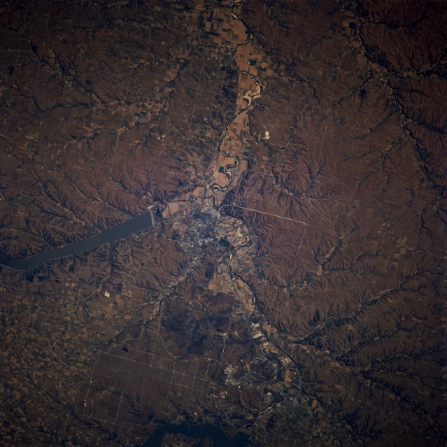 |
| STS073-716-083 Kansas River Valley and Manhattan, Kansas, U.S.A. October 1995 The Kansas River Valley and Manhattan are apparent in this east-looking, low-oblique photograph. Manhattan (center of photograph) sits at the confluence of the south-flowing Big Blue River and the east-flowing Kansas River. A trade and processing center for this rich farm area, its industries also include dress pattern production, food processing, and truck farming. Much of the economy is dependent on Kansas State University and nearby Fort Riley Army Base. Visible are Tuttle Creek Reservoir north of Manhattan and the northern extension of the grass-covered, rolling terrain of the Flint Hills to the south. |
| Images: | All Available Images Low-Resolution 345k |
|
| Mission: | STS073 |
|
| Roll - Frame: | 716 - 83 |
|
| Geographical Name: | USA-KANSAS |
|
| Features: | RIVERS,AGRICULTURE,RESERVOIRS |
|
| Center Lat x Lon: | 39.0N x 96.5W |
|
| Film Exposure: | N | N=Normal exposure, U=Under exposed, O=Over exposed, F=out of Focus |
| Percentage of Cloud Cover-CLDP: | 0 |
|
| Camera:: | HB |
|
| Camera Tilt: | 12 | LO=Low Oblique, HO=High Oblique, NV=Near Vertical |
| Camera Focal Length: | 250 |
|
| Nadir to Photo Center Direction: | NW | The direction from the nadir to the center point, N=North, S=South, E=East, W=West |
| Stereo?: | N | Y=Yes there is an adjacent picture of the same area, N=No there isn't |
| Orbit Number: | 115 |
|
| Date: | 19951027 | YYYYMMDD |
| Time: | 151517 | GMT HHMMSS |
| Nadir Lat: | 38.7N |
Latitude of suborbital point of spacecraft |
| Nadir Lon: | 96.1W |
Longitude of suborbital point of spacecraft |
| Sun Azimuth: | 133 | Clockwise angle in degrees from north to the sun measured at the nadir point |
| Space Craft Altitude: | 143 | nautical miles |
| Sun Elevation: | 25 | Angle in degrees between the horizon and the sun, measured at the nadir point |
| Land Views: | PLAIN, HILL |
|
| Water Views: | RIVER, LAKE |
|
| Atmosphere Views: | |
|
| Man Made Views: | URBAN AREA, DAM |
|
| City Views: | |
|
Photo is not associated with any sequences | ||
| NASA Home Page |
JSC Home Page |
JSC Digital Image Collection |
Earth Science & Remote Sensing |
|
This service is provided by the International Space Station program and the JSC Earth Science & Remote Sensing Unit, ARES Division, Exploration Integration Science Directorate.

|