
Geographic Region: USA-NEW YORK
Feature: NEW YORK, HUDSON RIVER
|
Geographic Region: USA-NEW YORK Feature: NEW YORK, HUDSON RIVER |
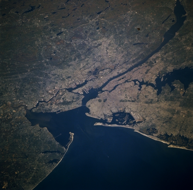 |
| STS073-707-0AA New York City Area, New York October 1995 Situated at the mouth of the Hudson River, the New York City Metropolitan area can be seen in this north-looking view. The New York Metropolitan area is the largest in the world. The region has the United States largest seaport area with extensive harbor facilities that total 755 miles (1217 km) of developed frontage. New York city is the world's foremost financial center and is headquarters to many major corporations. The city is also a mass communications center. The Hudson River can be seen entering the scene at the upper left (north) flowing south and emptying into Upper New York Bay near the center of the image. The Appalachian Mountains of northwestern New Jersey are visible covering the upper left and upper center of the image. The Atlantic Ocean covers the bottom center and bottom right of the image. From near the center of the image extending to the right center (east) of the image are Long Island and Long Island sound. |
| Images: | All Available Images Low-Resolution 305k |
|
| Mission: | STS073 |
|
| Roll - Frame: | 707 - AA |
|
| Geographical Name: | USA-NEW YORK |
|
| Features: | NEW YORK, HUDSON RIVER |
|
| Center Lat x Lon: | 40.5N x 74W |
|
| Film Exposure: | N | N=Normal exposure, U=Under exposed, O=Over exposed, F=out of Focus |
| Percentage of Cloud Cover-CLDP: | 0 |
|
| Camera:: | HB |
|
| Camera Tilt: | LO | LO=Low Oblique, HO=High Oblique, NV=Near Vertical |
| Camera Focal Length: | 100 |
|
| Nadir to Photo Center Direction: | The direction from the nadir to the center point, N=North, S=South, E=East, W=West |
|
| Stereo?: | Y | Y=Yes there is an adjacent picture of the same area, N=No there isn't |
| Orbit Number: | |
|
| Date: | 1995____ | YYYYMMDD |
| Time: | GMT HHMMSS |
|
| Nadir Lat: | N |
Latitude of suborbital point of spacecraft |
| Nadir Lon: | E |
Longitude of suborbital point of spacecraft |
| Sun Azimuth: | Clockwise angle in degrees from north to the sun measured at the nadir point |
|
| Space Craft Altitude: | nautical miles |
|
| Sun Elevation: | Angle in degrees between the horizon and the sun, measured at the nadir point |
|
| Land Views: | COAST, FOREST, HILL |
|
| Water Views: | BAY, RIVER |
|
| Atmosphere Views: | |
|
| Man Made Views: | URBAN AREA |
|
| City Views: | |
|
Photo is not associated with any sequences | ||
| NASA Home Page |
JSC Home Page |
JSC Digital Image Collection |
Earth Science & Remote Sensing |
|
This service is provided by the International Space Station program and the JSC Earth Science & Remote Sensing Unit, ARES Division, Exploration Integration Science Directorate.

|