
Geographic Region: USA-NEVADA
Feature: LAS VEGAS, MOUNTAINS
|
Geographic Region: USA-NEVADA Feature: LAS VEGAS, MOUNTAINS |
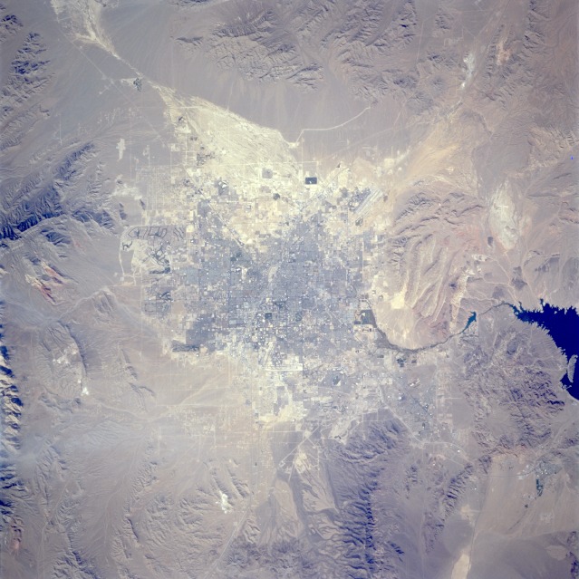 |
| STS073-706-020 Las Vegas, Nevada, U.S.A. September 1995 Las Vegas, known worldwide for its gambling casinos and its numerous hotels and other recreational features, is seen in this spectacular, near-vertical-looking photograph. The city was built in a small depression within a larger basin that is surrounded by mountain ranges. Major drainage into this basin appears as a white area northwest of the city. During occasional heavy rainfall, downtown Las Vegas is prone to flash flooding; the Strip, where many of the gambling casinos and hotels are located, is especially vulnerable. Viewing clockwise east to west, several features are visible-the blue waters of Lake Mead, the runways of Las Vegas International Airport at the south end of the city, the red cliffs of Red Rock Canyon, and residential expansion west and northwest of the city. Las Vegas has grown rapidly in the last three decades as a result of increased tourism and the influx of population from California and other states. |
| Images: | All Available Images Low-Resolution 128k |
|
| Mission: | STS073 |
|
| Roll - Frame: | 706 - 20 |
|
| Geographical Name: | USA-NEVADA |
|
| Features: | LAS VEGAS, MOUNTAINS |
|
| Center Lat x Lon: | 36.0N x 115W |
|
| Film Exposure: | N | N=Normal exposure, U=Under exposed, O=Over exposed, F=out of Focus |
| Percentage of Cloud Cover-CLDP: | 0 |
|
| Camera:: | HB |
|
| Camera Tilt: | 10 | LO=Low Oblique, HO=High Oblique, NV=Near Vertical |
| Camera Focal Length: | 250 |
|
| Nadir to Photo Center Direction: | NW | The direction from the nadir to the center point, N=North, S=South, E=East, W=West |
| Stereo?: | Y | Y=Yes there is an adjacent picture of the same area, N=No there isn't |
| Orbit Number: | 37 |
|
| Date: | 19951022 | YYYYMMDD |
| Time: | 200704 | GMT HHMMSS |
| Nadir Lat: | 35.8N |
Latitude of suborbital point of spacecraft |
| Nadir Lon: | 114.6W |
Longitude of suborbital point of spacecraft |
| Sun Azimuth: | 195 | Clockwise angle in degrees from north to the sun measured at the nadir point |
| Space Craft Altitude: | 146 | nautical miles |
| Sun Elevation: | 42 | Angle in degrees between the horizon and the sun, measured at the nadir point |
| Land Views: | DESERT, MOUNTAIN, BASIN |
|
| Water Views: | |
|
| Atmosphere Views: | |
|
| Man Made Views: | URBAN AREA, AIRPORT |
|
| City Views: | LAS VEGAS |
|
Photo is not associated with any sequences | ||
| NASA Home Page |
JSC Home Page |
JSC Digital Image Collection |
Earth Science & Remote Sensing |
|
This service is provided by the International Space Station program and the JSC Earth Science & Remote Sensing Unit, ARES Division, Exploration Integration Science Directorate.

|