
Geographic Region: USA-MISSOURI
Feature: MS & ILLINOIS RIVERS,AGR
|
Geographic Region: USA-MISSOURI Feature: MS & ILLINOIS RIVERS,AGR |
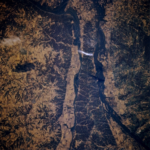 |
| STS073-705-099 Mississippi and Illinois Rivers, Illinois, U.S.A. October 1995 The valleys of the Illinois River (center) and the Mississippi River (west of the Illinois River) are apparent in this near-vertical photograph. Agricultural field patterns dot both river valleys, depicting a recovery from the devastating floods of the spring and summer of 1993. More than 20 000 years ago, this part of the Illinois River was the main course of the Mississippi River. The continental glacier that covered most of Illinois to the east shifted the Mississippi River westward to its present course. North of the rivers' confluence is hilly, forested Pere Marquette State Park, the largest state park in Illinois. |
| Images: | All Available Images Low-Resolution 406k |
|
| Mission: | STS073 |
|
| Roll - Frame: | 705 - 99 |
|
| Geographical Name: | USA-MISSOURI |
|
| Features: | MS & ILLINOIS RIVERS,AGR |
|
| Center Lat x Lon: | 39.0N x 90.5W |
|
| Film Exposure: | N | N=Normal exposure, U=Under exposed, O=Over exposed, F=out of Focus |
| Percentage of Cloud Cover-CLDP: | 0 |
|
| Camera:: | HB |
|
| Camera Tilt: | 19 | LO=Low Oblique, HO=High Oblique, NV=Near Vertical |
| Camera Focal Length: | 250 |
|
| Nadir to Photo Center Direction: | W | The direction from the nadir to the center point, N=North, S=South, E=East, W=West |
| Stereo?: | Y | Y=Yes there is an adjacent picture of the same area, N=No there isn't |
| Orbit Number: | 83 |
|
| Date: | 19951025 | YYYYMMDD |
| Time: | 152207 | GMT HHMMSS |
| Nadir Lat: | 39.1N |
Latitude of suborbital point of spacecraft |
| Nadir Lon: | 89.7W |
Longitude of suborbital point of spacecraft |
| Sun Azimuth: | 140 | Clockwise angle in degrees from north to the sun measured at the nadir point |
| Space Craft Altitude: | 144 | nautical miles |
| Sun Elevation: | 29 | Angle in degrees between the horizon and the sun, measured at the nadir point |
| Land Views: | VALLEY |
|
| Water Views: | RIVER |
|
| Atmosphere Views: | |
|
| Man Made Views: | |
|
| City Views: | |
|
Photo is not associated with any sequences | ||
| NASA Home Page |
JSC Home Page |
JSC Digital Image Collection |
Earth Science & Remote Sensing |
|
This service is provided by the International Space Station program and the JSC Earth Science & Remote Sensing Unit, ARES Division, Exploration Integration Science Directorate.

|