
Geographic Region: USA-OHIO
Feature: CINCINNATI,OHIO R.,AGR.
|
Geographic Region: USA-OHIO Feature: CINCINNATI,OHIO R.,AGR. |
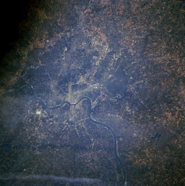 |
| STS073-704-056 Ohio River and Cincinnati, Ohio, U.S.A. October 1995 Cincinnati, Ohio, and Covington, Kentucky, are apparent in this north-northwest-looking, low-oblique photograph. Situated on the north side of the Ohio River is Cincinnati, an industrial, commercial, and cultural center with a large riverfront and good transportation facilities. The city suffered from severe floods in 1884 and 1937, but federal and state flood control projects have greatly reduced flooding dangers. Cincinnati was home to William Howard Taft, 27th president of the United States. Covington, Kentucky, lies on the south bank of the Ohio River. It, too, is an industrial city with a large riverfront and good transportation facilities. The Cincinnati-Northern Kentucky International Airport lies west of Covington (midway between center and left center). |
| Images: | All Available Images Low-Resolution 347k |
|
| Mission: | STS073 |
|
| Roll - Frame: | 704 - 56 |
|
| Geographical Name: | USA-OHIO |
|
| Features: | CINCINNATI,OHIO R.,AGR. |
|
| Center Lat x Lon: | 39.0N x 84W |
|
| Film Exposure: | N | N=Normal exposure, U=Under exposed, O=Over exposed, F=out of Focus |
| Percentage of Cloud Cover-CLDP: | 5 |
|
| Camera:: | HB |
|
| Camera Tilt: | 21 | LO=Low Oblique, HO=High Oblique, NV=Near Vertical |
| Camera Focal Length: | 250 |
|
| Nadir to Photo Center Direction: | NW | The direction from the nadir to the center point, N=North, S=South, E=East, W=West |
| Stereo?: | Y | Y=Yes there is an adjacent picture of the same area, N=No there isn't |
| Orbit Number: | 35 |
|
| Date: | 19951022 | YYYYMMDD |
| Time: | 170410 | GMT HHMMSS |
| Nadir Lat: | 38.5N |
Latitude of suborbital point of spacecraft |
| Nadir Lon: | 83.2W |
Longitude of suborbital point of spacecraft |
| Sun Azimuth: | 176 | Clockwise angle in degrees from north to the sun measured at the nadir point |
| Space Craft Altitude: | 146 | nautical miles |
| Sun Elevation: | 41 | Angle in degrees between the horizon and the sun, measured at the nadir point |
| Land Views: | |
|
| Water Views: | RIVER |
|
| Atmosphere Views: | |
|
| Man Made Views: | URBAN AREA, AIRPORT |
|
| City Views: | CINCINNATI, COVINGTON |
|
Photo is not associated with any sequences | ||
| NASA Home Page |
JSC Home Page |
JSC Digital Image Collection |
Earth Science & Remote Sensing |
|
This service is provided by the International Space Station program and the JSC Earth Science & Remote Sensing Unit, ARES Division, Exploration Integration Science Directorate.

|